EarthDaily for Property Risk Insurance
From Uncertainty to Insight: Transforming Insurance with Risk Data
Enabling carriers and reinsurers to seamlessly integrate geospatial data into their decision making
We Understand
Advanced Risk Solutions for Insurers
Today's insurance industry faces unprecedented challenges due to the increasing frequency and severity of natural disasters.
Coincidentally, the industry also stands on the brink of a new era of transformation which integrates of-the-moment geospatial data into their processes. However, insurance carriers struggle to truly capitalize on this wealth of information due to legacy systems and outdated and fragmented data sources.
Earth Observation (EO) data and advanced analytics offer a solution, enabling insurers to improve underwriting, speed up claims processing, and boost efficiency.
Easy to Access Data

Innovation for Property Risk Insurance
Earth Observation: A Key Tool for Modern Insurance
EO data, collected via satellite imagery and sensors, provides invaluable insights into environmental conditions, property exposures, and potential hazards. However, the complexity, fragmentation, and potential inaccuracies of this data can create additional work and reduce efficiency. Access to accurate, analysis-ready data is essential for insurers to navigate today's risks and stay ahead.
Explore Our Products and Solutions for the Insurance Industry
Learn how Ascend, our geospatial enterprise platform for portfolio management, empowers the entire insurance value chain through simplified integration of geospatial data.
Our Property Risk Product
Introducing Ascend: Your Geospatial Advantage
Ascend is a cutting-edge platform designed specifically for insurance. It empowers insurers to seamlessly integrate EO data for actionable insights and informed decisions.
Enhance Risk Assessment and Underwriting
Use high-res satellite imagery to evaluate property conditions, identify risk, and accurately price premiums.
Streamline Claims Management
Access near real-time data post-catastrophe to assess damages swiftly, validate claims, and reduce fraud.
Monitor Catastrophic Events
Track events such as floods, wildfires, and hurricanes in real-time to manage exposure and respond proactively.
Inform Infrastructure and Investment Decisions
Analyze environmental data to guide strategic investments and infrastructure development.

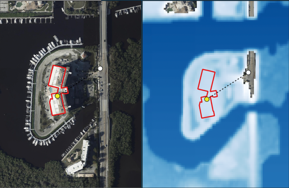
Original carrier policy location showed no flooding but the corrected geocoded location shows 0.92m of flooding. The blue layer is Iceye flood data from Hurricane Ian. The difference between the two locations was 114 meters. The problem was due to error in original geocoding which put location on road in front of building.
Flood data supplied by ICEYE.
Why Ascend for Insurance?
- Comprehensive Data Integration: Ascend merges satellite, drone, and aerial imagery with property characteristics and climate models, offering a holistic view of risks and exposures.
- Dynamic Data Fusion: The platform dynamically selects and validates data from over 42+ partnerships and 4,000 attributes, ensuring insurers have access to the most accurate and relevant information.
- Seamless Workflow Integration: Ascend integrates effortlessly into existing insurance processing ecosystems, enhancing underwriting, claims management, and customer experience without disrupting current operations.
- Real-Time Post-Catastrophe Analysis: Obtain detailed assessments within hours of a catastrophic event, facilitating prompt claims processing and customer support.
EarthDaily Data Layers:
Improved Modeling of Natural Catastrophes
The upcoming EarthDaily Constellation will enhance our current offerings for our insurance customers. The daily, global coverage will power more in-depth insights for natural disasters that impact the insurance industry, particularly for wildfires and flooding, giving a more persistent, accurate measure of risk to improve and proactively mitigate predictions.
EarthDaily also partners with a number of data providers to create a "virtual constellation" of complementary datasets to empower our customers' analyses. This includes weather & atmospheric data, SAR data, and digital elevation models to improve the value of geospatial data for the insurance industry.


Making Spatial Data Useful
In an era where data-driven decision-making is paramount, Ascend offers:
Unmatched Data Accuracy
Access to the most current and precise geospatial data available.Customized Solutions
Tailored analytics to meet the unique needs of carriers, reinsurers, and brokers.
Scalable Technology
A platform designed to grow with your business, adapting to evolving challenges and opportunities.
Take the Next Step Towards Innovation
Embrace the future of insurance with EarthDaily’s powerful capabilities for the insurance industry, including our flagship insurance software, Ascend. Transform your risk assessment and claims management processes with cutting-edge geospatial data and analytics.