This summer, NASA’s Airborne Visible/Infrared Imaging Spectrometer (AVIRIS) campaigns flew extensively over Nevada, Arizona, and surrounding states, capturing some of the highest fidelity airborne hyperspectral data ever collected for mineral exploration. The addition of the new AVIRIS 5 sensor in the coming months, alongside freshly collected AVIRIS Classic and AVIRIS NG data, represents a leap forward in public hyperspectral imaging. At EarthDaily, we’ve been busy processing AVIRIS data with our Marigold exploration software for over two years, and the results are proving transformative.
What This Means for Exploration Geologists
Expanded Coverage
This summer’s campaign is significantly expanding the AVIRIS Classic archive across Nevada, Arizona, and neighboring states. Importantly, new flight lines collected with AVIRIS Classic are being mirrored by AVIRIS 5 flights over the same areas. This dual collection effort not only strengthens continuity with the historical AVIRIS record but also provides immediate comparison with the newest sensor. These datasets are expected to be available to the public in the coming months, creating an unprecedented regional scale resource for exploration geologists.
Spectral and Spatial Resolution with AVIRIS 5
AVIRIS 5 is the newest successor to the original AVIRIS Classic, delivering significantly improved performance in both spectral sampling and spatial resolution. While AVIRIS Classic provided 224 spectral channels, AVIRIS 5 expands this to 425 channels with a finer 5 nm spectral resolution. In addition, AVIRIS 5 achieves 8 meter spatial resolution, a substantial improvement over the coarser resolution of orbital systems like ASTER, EnMAP, and PRISMA. The combination of fine spectral detail and sharp spatial clarity makes AVIRIS 5 one of the highest resolution regional scale hyperspectral datasets available across North America. For explorers, this translates to clearer mineral discrimination, better alteration mapping, and higher confidence in targeting decisions.
Integration with Marigold
Processing hyperspectral datasets of this scale and complexity requires specialized tools. Marigold is the preferred remote sensing software for working with AVIRIS data, enabling explorers to translate raw spectral information into actionable mineral insights. From unsupervised classifications to advanced mineral mapping, Marigold allows geologists to seamlessly integrate AVIRIS outputs into exploration workflows, combining them with geochemistry, magnetics, and structural datasets.
Looking Ahead
The scope of AVIRIS coverage is set to grow even further. In 2026, campaigns will expand into additional states including Utah, Wyoming, Idaho, Colorado, and New Mexico, providing explorers with a continuous, regional scale dataset across much of the western U.S. This forward looking expansion reinforces the strategic importance of AVIRIS data for mineral exploration and critical mineral assessments.
Practical Outcomes
-
Sharper alteration mapping for porphyry and epithermal systems
-
Stronger exploration vectors based on mineral associations
-
More confident targeting decisions across some of North America’s most prospective ground
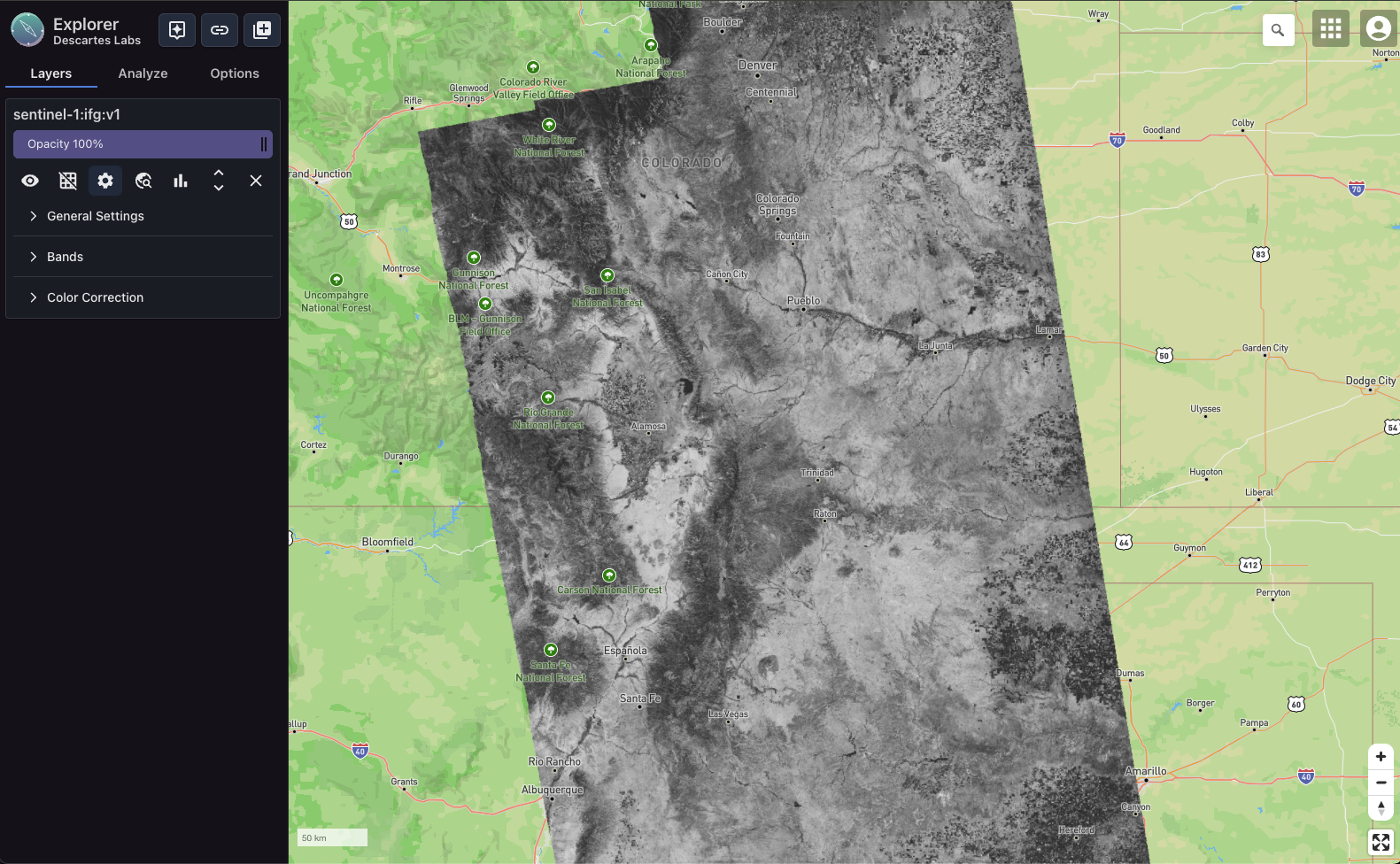
Example: AVIRIS Data in Marigold

Minimum Noise Fraction (MNF) classification generated in Marigold using AVIRIS Classic data. Color is a proxy for composition.
In this example, spectrally similar pixels are grouped using an unsupervised MNF classification. Spectral interrogation reveals minerals such as pyrophyllite, muscovite, illite, and chlorite which are key vectors for porphyry and epithermal deposits. By targeting these minerals, explorers can identify proximal and distal relationships and take a mineral systems approach to discovery, helping field teams vector toward ore.
Why It Matters Now
Explorers working in Nevada, Arizona, or the broader Western U.S. should evaluate how to integrate this summer’s AVIRIS coverage into their exploration workflows. With the combination of expanded coverage, improved resolution, and advanced processing through Marigold, there is a first mover advantage: refining exploration targets and updating mineral system models with unmatched confidence.
Sources
NASA JPL AVIRIS Campaigns – Geological Earth Mapping Experiment (GEMx)
NASA Earth Science Division – Airborne Campaign Schedule
NASA Scientific Visualization Studio – AVIRIS Campaigns Over the U.S. West