.jpg?width=289&height=168&name=Data%20Use%20cases%20(1).jpg)
Wildfire seasons are changing in ways that show up plainly in the numbers. Canada’s recent fire seasons show how much things have shifted. In 2023, 17.3 million hectares burned, which is the largest total ever recorded and more than eight times the long-term average. The 2025 season followed in the same direction to quickly become the second worst.
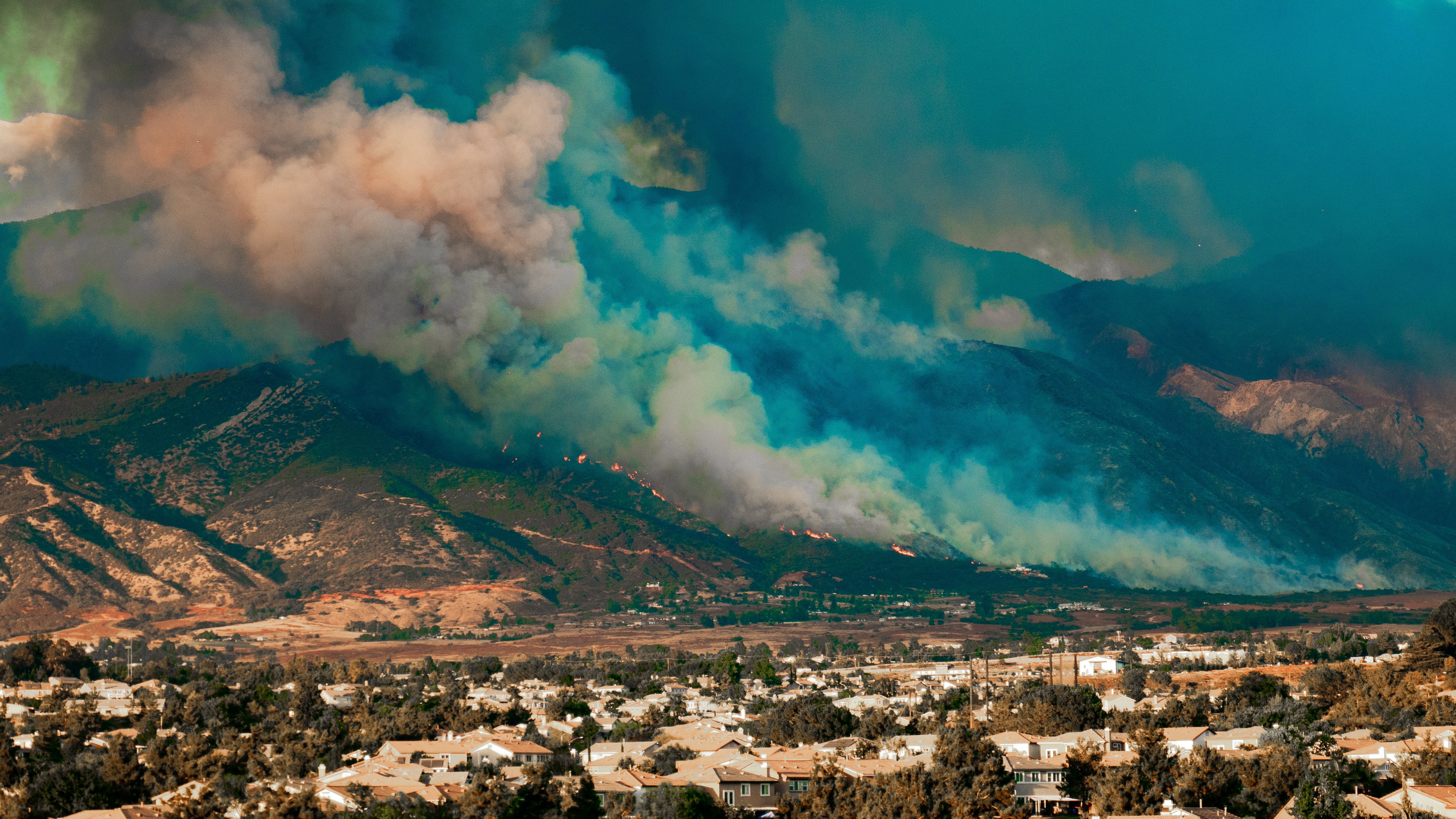
In the United States, the picture is just as worrying. More than a third of American homes now fall inside wildfire-prone areas. Fires like the Palisades incident made that visible: dry vegetation carried flames right into built-up neighbourhoods, leaving whole blocks destroyed.
Similar trends are emerging elsewhere — in Europe, Australia, and South America. Longer warm periods and extended dryness are creating conditions where fires start more readily and burn with far more intensity than they used to.
Why Traditional Models Fall Behind
For years, wildfire risk was assessed through the lens of history. Burn scars, event footprints, and proximity scores shaped how exposure was understood. In a period when landscapes shifted slowly and fuel conditions followed more predictable patterns, that approach was enough to give a reasonable sense of risk.
That’s no longer the case. Warmer temperatures, longer dry spells, and repeated stress events are changing how landscapes behave. Fuel dries out unevenly and much sooner than expected. Vegetation that once recovered between seasons now stays weakened for longer stretches. Soil moisture can drop quickly during extended warm periods and take months to return. These shifts don’t align neatly with seasonal expectations, and they vary widely from region to region. Static maps and historical layers struggle to reflect what is happening on the ground today.
Across regions, measuring fuel, dryness, and vegetation stress at scale remains challenging, which means environmental signals often arrive unevenly or too late. As landscapes change faster, the systems used to understand wildfire risk need to catch up, and that depends on clearer, more consistent environmental insight.
The Data Behind a Modern Wildfire Model
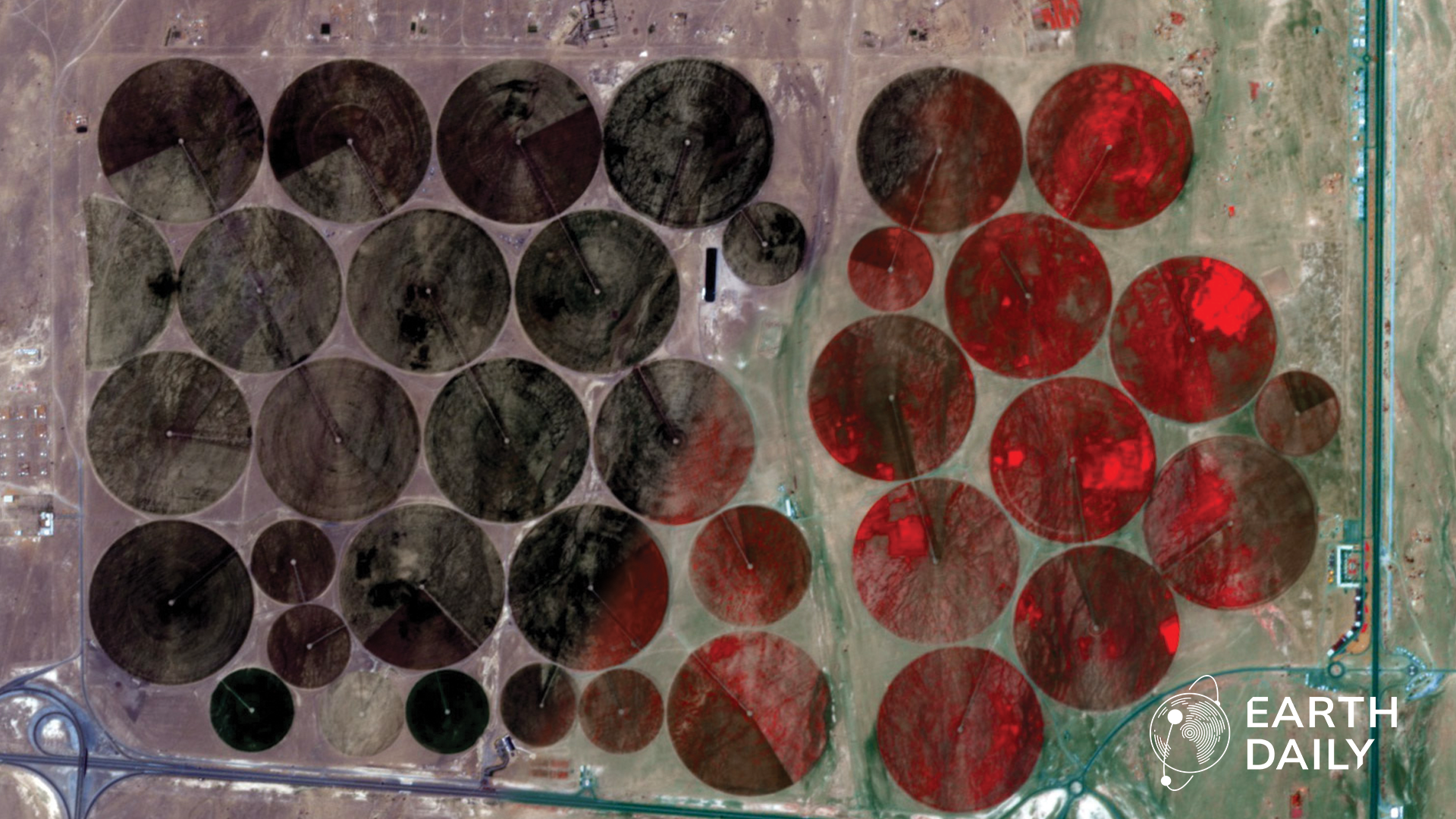
A modern wildfire model needs to move with the landscape, which most traditional models struggle to do because the underlying environmental data is too infrequent or incomplete. Capturing how fuels, vegetation, moisture, terrain, and weather change over time requires calibrated, frequent insight into all the factors that shape susceptibility.
EarthDaily’s data platform brings these inputs together through a combination of optical, radar, and other satellite datasets; digital elevation models; high-resolution land-cover information; soil and moisture layers; and weather and atmospheric data. These sources are integrated with insights from more than 42 upstream data partners and over 4,000 environmental attributes, selected and validated through a unified calibration and data-fusion pipeline.

This virtual constellation approach delivers a consistent, high-revisit stream of observations, including land-surface temperature, that help track how fuel, moisture, and stress change through time. These layers reveal early signals of vegetative stress, moisture loss, heat buildup, and the structural features that shape how fire might travel. Together, they form the foundation for a model of wildfire susceptibility anchored in environmental conditions.
The upcoming EarthDaily satellite constellation will expand this capability further. The constellation’s 10 satellites will provide daily global coverage across 22 spectral bands, a design focused on measuring vegetation stress, surface moisture, and other signals essential for understanding environmental change. Once operational, the constellation will deepen the temporal and spectral detail available for fuels-based modelling at both regional and global scales.
Dynamic Modelling for Changing Landscapes
EarthDaily’s modelling framework starts with the conditions that shape wildfire behaviour, be it fuel, dryness, vegetation structure, terrain, or weather, and how they shift over time. This framework underpins Ascend, EarthDaily’s geospatial enterprise platform that brings environmental signals together into a single, evolving view.
As new observations arrive, the model updates, allowing susceptibility to be tracked as the landscape shifts.

That environmental view can support a range of decisions. In insurance settings, it can translate these signals into asset-level risk scores and portfolio-level exposure views, offering a consistent picture across individual properties, regions, and national books of business. The modelling pipeline is transparent and defensible, with drivers such as fuel load, moisture, vegetation stress, slope, and structure surfaced directly so underwriters and analysts can see how risk is forming and why a location is classified the way it is.
The Growing Cost of Wildfires
Wildfire rarely moves through healthy, recovered forests anymore. Much of the land it burns is already worn down by heat, slow regrowth, or stress that builds from one season to the next. Between 2001 and 2024, fires were responsible for more than 150 million hectares of global tree-cover loss. In 2024 alone that number hit 13 million hectares, almost half of everything the world lost that year.
When recovery slows and fuel collects, fires come back faster, and they travel farther. Agencies responsible for forests, land use, and even power and utility corridors now have to watch not just where a fire starts, but where the landscape is failing to bounce back.
For insurers, these same environmental shifts appear in a different form: as uncertainty in exposure and loss. Wildfires now cause billions of dollars in economic damages, adding up to more than US$ 136 billion globally between 2015 and 2024. In the first half of 2025 alone, insured natural-catastrophe losses reached US$ 80 billion worldwide, with U.S. wildfires contributing significantly.
Risk is easier to work with when you can trace how it forms. When environmental intelligence updates as conditions change, insurers and public agencies can see where landscapes are becoming more susceptible and where assets or communities sit in that path. It doesn’t settle the volatility, but it makes it easier to understand and manage.