Earth Observation: EarthPipeline
Streamline Earth Observation Data Processing
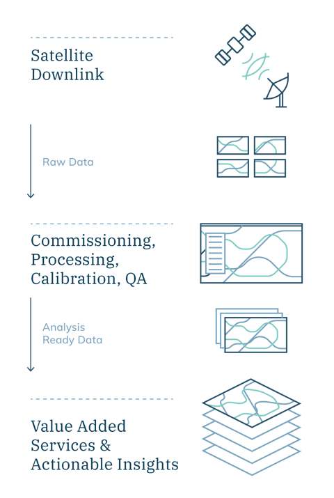
Transform raw satellite data into actionable insights with EarthPipeline—the ultimate solution for analysis-ready Earth observation data. Powering the EarthDaily Constellation, EarthPipeline ensures high-quality, consistent, and scalable data for next-gen applications.

Simplifying Access to Earth Observation Data
Satellite data can be overwhelming: massive volumes, often disorganized and fragmented, making it hard to find the insights you need.
Stop wasting time wrestling with raw satellite data. EarthDaily delivers the actionable intelligence you need to make rapid, informed decisions. We handle the complex processing so you don't have to.
Advanced Calibration and Processing with EarthPipeline
EarthPipeline simplifies the process of turning raw satellite data (both optical and SAR) into usable insights empowering you to maximize the value of your Earth observation assets. Regardless of satellite size or onboard imaging system, our automated system generates Analysis Ready Data (ARD) products, allowing you to efficiently manage your data and get straight to analysis.
Radiometric accuracy is crucial for deriving quantifiable change and actionable insights without false positives. EarthPipeline delivers scientific quality radiometrically accurate products designed for geoanalytics.
With EarthPipeline, you can efficiently manage satellite data and generate ARD products that are ready for immediate use in downstream analytical applications.
Transform Your Satellite Data Today
Discover how EarthPipeline can help you scale and deliver high-quality, analysis-ready data.
Seamless Integration
EarthPipeline powers the EarthDaily Constellation (EDC), offering the scale and reliability required to meet future Earth Observation data needs.
Comprehensive Data Solutions
Designed for New Space Providers, innovation hubs, and emerging satellite vendors, EarthPipeline transforms complex spatial data into standardized and ready-to-use formats.
Market-Leading Data Accuracy
Achieve consistently calibrated, high-quality mosaics that deliver actionable insights for industries such as agriculture, defense, and environmental monitoring.
Why Choose EarthPipeline?
- Efficient Data Processing: Automatic calibration and processing for both optical and SAR data.
- Scalable & Future-Proof: Built to support the EarthDaily Constellation and adaptable for other EO satellite constellations.
- Analysis-Ready Output: Delivers high-quality data in formats optimized for advanced AI and analytics.
- Cost-Effective for New Space Providers: Delivers high-quality from lower cost GPS, star trackers, and payloads.
Ready for scalable, future-proof data solutions?
Talk to our experts and learn how EarthPipeline can optimize your satellite operations.


Make better decisions, quickly.
EarthPipeline gives satellite providers exactly what they need: faster, higher-quality data that’s AI-ready and scalable for future applications.
EarthDaily has already invested in a high-performance system to eliminate complexity and reduce processing time. With EarthPipeline, get your data into the hands of decision-makers faster, with accuracy you can trust.
Future-Proof Your Data with EarthPipeline
Whether you're an emerging New Space provider or an established player in the Earth observation market, EarthPipeline equips you to harness the full potential of your satellite data.
Contact us today to learn how EarthPipeline can help you scale and deliver better data products for your customers.