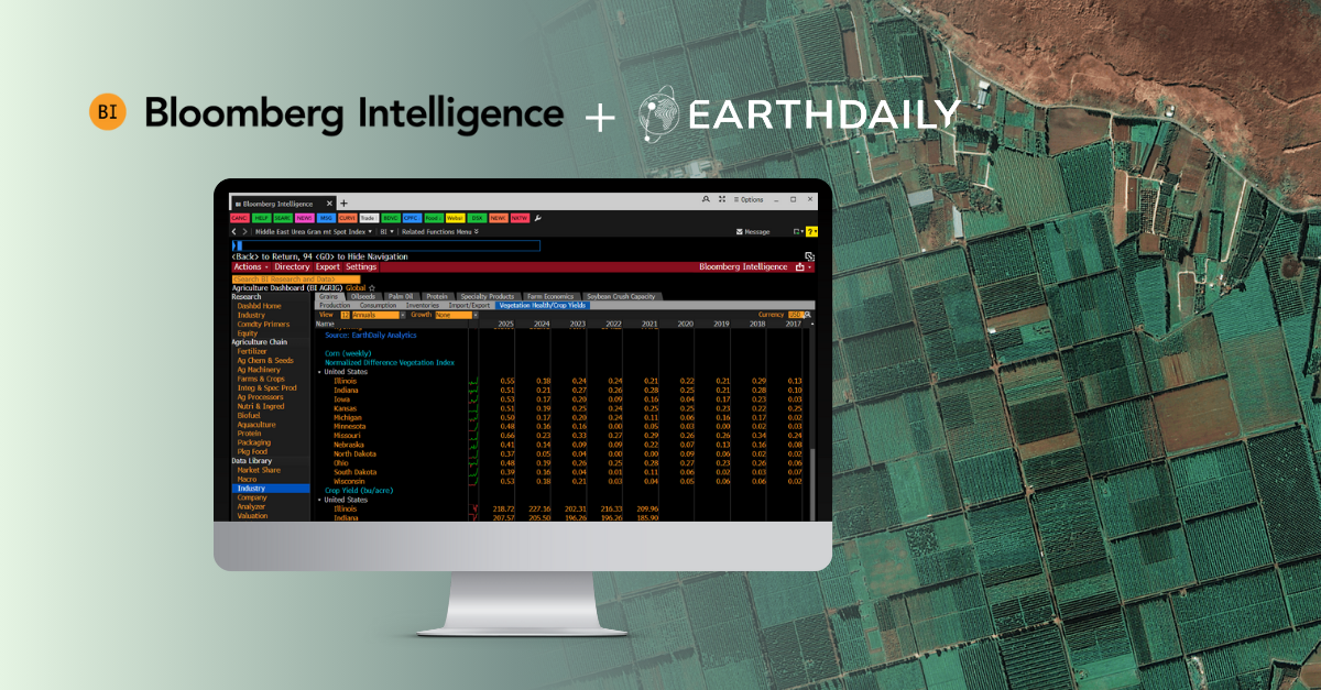
SE Carbon Project: Harnessing Earth Observation for Ecosystem Resilience, Carbon Sequestration and Alternative Energy 

Introduction 

The SE Carbon Project represents a pioneering collaboration between EarthDaily Analytics and Strategic Systems Engineering (SSE), generously supported by the Canadian Space Agency (CSA). This project aims to develop natural infrastructure solutions to combat climate change and address key environmental challenges and will leverage Earth Observation data, namely sources with sufficient spectral breadth and revisit capabilities, to accomplish this feat. 

Project Significance and Objectives 

This groundbreaking project addresses the urgent challenges confronting local and regional stakeholders in agriculture and the environment. Paramount among these challenges are the imperative to mitigate greenhouse gas emissions, the necessity to intercept and recycle agricultural nutrients to safeguard fragile aquatic ecosystems, and the pressing need to increase infrastructure, ecosystem, and market resilience against the escalating impacts of climate change. The SE Carbon Project offers a holistic solution by synergizing satellite-derived geospatial analytics with cutting-edge hydrologic engineering technologies. By harnessing Earth Observation data, the project aims to deliver actionable insights and sustainable solutions for a climate-resilient future. 

The primary objectives of the SE Carbon project include: 

  1. Developing a space-based Earth Observation application to quantify carbon sequestration and excess phosphorus bioremediation capacity through natural infrastructure solutions. 
  1. Identifying features of artificial or linear wetlands that can be detected from space. 
  1. Quantifying the spatial and spectral requirements for estimating carbon and phosphorus sequestration. 
  1. Providing recommendations on data sources and methods for wide-scale quantification of these environmental benefits. 

Our Role in the Project 

EarthDaily Analytics plays a crucial role in this collaboration by utilizing high-frequency multi-spectral imagery to detect the presence and growth rate of wetland plants, such as Typha or more commonly known as Cattails. These plants are particularly adept at absorbing and processing nutrients originating from agricultural runoff. Leveraging our advanced imaging capabilities, this innovative initiative seeks to repurpose underutilized, frequently inundated lands as strategic biomass harvesting zones. This data is essential for SSE’s macrophyte biomass harvesting program, which aims to repurpose low-value, frequently flooded land as biomass harvesting zones.  
 

Agricultural runoff is a significant contributor to water pollution, with nutrients like phosphorus and nitrogen posing grave threats to aquatic ecosystems. Eutrophication, fueled by excessive nutrient input, leads to the rapid growth of algae and subsequent oxygen depletion in water bodies, resulting in fish kills and ecosystem degradation. In fact, according to the EPA, agricultural runoff is the leading source of water quality impairments in rivers and lakes across the United States with 65% of studied coastal waters and estuaries being severely degraded by excessive nutrients, resulting in $2.2 billion in damages annually. 
 
By repurposing nutrient-rich biomass harvested from these designated zones, we contribute to the mitigation of agricultural runoff’s adverse effects. This biomass, abundant in nutrients and carbon content, serves as a renewable resource for applications such as space heating fuel and biochar production. Furthermore, this endeavor facilitates carbon sequestration in soil, thereby mitigating the phosphorus pollution responsible for exacerbating eutrophication in lakes and waterways. 

Detailed Findings and Technical Advancements 

The project has achieved significant progress in various technical areas: 

  1. Image Processing and Typha Classification: Advanced image processing techniques have been employed to enhance the accuracy of Typha classification. The use of Random Forest models has proven effective in generating monthly Typha classification maps, providing valuable data for biomass harvesting. 
  1. NDVI Analysis: The project has utilized NDVI analysis to monitor the greenness of Typha and other vegetation types over time. This analysis helps in understanding the growth patterns of Typha and its potential for biomass production. 
  1. Biomass Estimation: Using NDVI values from Sentinel 2 and SPOT images, biomass models have been developed to estimate the biomass produced by Typha. This information is crucial for assessing the carbon sequestration potential of harvested biomass. 
  1. Wetland Classification: In addition to Typha classification, the project has focused on wetland classification using the ABMI wetland inventory. This classification is essential for identifying potential areas for natural infrastructure solutions. 
  1. Production-Ready System Development: The project has developed a production-ready system that adheres to principles of generalization, scalability, efficiency, and parameterization. This system ensures the seamless integration of future data processing steps and the continuous delivery and monitoring of models in production. 

Project Outcomes and Conclusion 

The partnership between EarthDaily Analytics and SSE, with the invaluable support of the CSA, exemplifies the power of integrating remote sensing technology with environmental engineering proficiency to address complex challenges. With the imminent launch of the EarthDaily Constellation, the scalability of these Earth Observation-driven methodologies to global markets heralds a new era of environmental management solutions. The SE Carbon Project stands as a beacon of progress towards a sustainable future, showcasing how collaborative efforts and a steadfast commitment to environmental stewardship can yield tangible solutions that concurrently benefit agriculture and the natural environment. By harnessing the combined expertise of EarthDaily Analytics and SSE, supported by the CSA, this project underscores the transformative potential of integrating Earth Observation data with advanced engineering solutions. As we collectively strive towards a greener, more resilient planet, initiatives like the SE Carbon Project illuminate the path forward, demonstrating the profound impact of interdisciplinary collaboration on shaping a sustainable tomorrow. 

(VIDEO) NDVI Changes Jul to Oct 

Share

Next Steps

—Ready to talk to us? Contact Us
—Want to hear more from us? Sign up for our newsletter