Maritime:
Scalable Anomaly Detection Across the World's Oceans

Maritime delivers tailored Earth Observation data built for quick, scalable processing and detection of maritime anomalies. Purpose-optimized for ocean and coastal change detection, Maritime provides the efficient, consistent imagery needed to power vessel detection, behavioral analysis, and coastal monitoring across the world's waterways—every single day.

earthdaily-data-maritime-satellite-imagery

Detect What Matters Across Millions of Square Kilometers

Purpose-built for maritime operations, Maritime provides security organizations, analytics providers, and coastal agencies with streamlined satellite imagery optimized for scalable anomaly detection. Global daily coverage, processing efficiency, detection-ready delivery.

  • Optimized Spectral Configuration
    Maritime's focused 4-band configuration—Blue, Green, Red, NIR—delivers the spectral signatures essential for vessel detection, wake analysis, and coastal change identification. No unnecessary bands consuming processing cycles on information your detection workflows don't need.


  • Efficient Data Architecture
    Designed for delivery at scale, our data architecture enables rapid deployment across millions of square kilometers — so maritime monitoring programs can be stood up quickly, without compromise.


  • Built on the EarthDaily Constellation
    Powered by the 10-satellite EarthDaily Constellation, Maritime delivers market-leading signal-to-noise ratio and consistent coverage across the world's oceans. Ten years of imaging continuity ensures your maritime monitoring programs operate on a stable, reliable foundation.

Why Choose Maritime for Ocean Monitoring

earthdaily-data-maritime-satellite-data-australia
earthdaily-data-maritime-spectral-bands

Purpose-Built Spectral Configuration:
The streamlined 4-band, 8-bit configuration delivers detection-essential spectral information while enabling rapid processing of vast ocean areas where efficiency matters most.

earthdaily-data-maritime-detection-ready

Precise Calibration Foundation:
Rigorous geometric and radiometric correction ensures reliable, repeatable measurements across the constellation—essential for time-series analysis, change detection, and quantitative remote sensing.

earthdaily-data-maritime-surveillance

Seamless Analytics Integration:
Standard formats, STAC-compliant cataloging, and API delivery integrate directly into vessel detection algorithms, change detection workflows, and maritime intelligence platforms.

Core Capabilities
From Satellite Acquisition to Maritime Intelligence

Maritime data undergoes rigorous calibration and processing optimized for change detection across ocean and coastal environments.

Tick Icon, indicating to the user the availability of a feature.

Radiometric Calibration
Sensor-level calibration ensures consistent radiometric response across the constellation, enabling reliable vessel detection and change analysis regardless of which satellite captures the imagery.

Tick Icon, indicating to the user the availability of a feature.
Low Latency Delivery
Rapid processing pipelines move imagery from acquisition to detection-ready data quickly, supporting time-critical maritime workflows including vessel tracking, anomaly response, and AIS correlation.
Tick Icon, indicating to the user the availability of a feature.
Cloud Detection

Cloud mask layers identify obscured areas, enabling automated filtering and maximizing usable coverage across maritime regions where weather variability impacts observations.
Tick Icon, indicating to the user the availability of a feature.
Maritime Optimization

Processing parameters tuned for maritime environments deliver optimal contrast and detail for vessel detection, wake identification, and coastal feature extraction.

Seamless Integration with Maritime Systems

earthdaily-data-maritime-satellite-data-coast
earthdaily-data-maritime-satellite-data
earthdaily-data-maritime-satellite-data-port
Standard Data Formats:
GeoTIFF delivery ensures compatibility with remote sensing software, custom processing chains, and analytical pipelines
STAC-Compliant Catalog:
SpatioTemporal Asset Catalog implementation enables standardized discovery and programmatic access
Cloud-Native Access:
Cloud Optimized GeoTIFFs stream directly into processing environments
API Integration:
RESTful endpoints and Python client library support automated ingestion into operational workflows
Calibration Metadata:
Complete radiometric and geometric calibration parameters delivered with imagery

Coverage & Availability

Global Daily Maritime Operations

Coverage Area:
All maritime regions, coastlines, and exclusive economic zones worldwide

Revisit Frequency:
Daily at consistent local solar time

Viewing Geometry:
Nadir (consistent look angle across constellation)

Swath Width:
240 km per satellite pass

Spectral Bands

Visible

Coastal
Blue
Aqua
Green
Yellow

Near Infrared

Red
Red Edge 1
Red Edge 2
Red Edge 3
Near Infrared

Shortwave Infrared

Water Vapour 1
Water Vapour 2
SWIR 1
Cirrus
SWIR 2
Methane 1
Methane 2

Thermal Infrared

Wildfire
TIR 1
TIR 2
TIR 3
TIR 4

Science Features & Capabilities
Precise Calibration. Complete Control.

earthdaily-data-maritime-5m-ground-sample
5-Meter Ground Sample Distance

Resolution optimized for vessel detection, port monitoring, and coastal change analysis across strategic maritime areas

earthdaily-data-maritime-4-spectral-bands
4-Band Multispectral Imaging:

Blue, Green, Red, and NIR bands deliver detection-essential spectral information

earthdaily-data-maritime-l1-processing
L1 Processing Level:

Radiometrically and geometrically corrected data ready for integration into your maritime analytics pipelines

earthdaily-data-maritime-cloud-masks
Consistent Acquisition Geometry:
Fixed local solar time and nadir viewing angle across acquisitions enables reliable temporal analysis and change detection
earthdaily-data-maritime-persistent-monitoring
Persistent Monitoring Capability:
Daily revisit supports pattern-of-life analysis, behavioral anomaly detection, and continuous situational awareness
earthdaily-data-maritime-wide-swaths
Wide-Area Swath
240 km swath width provides efficient coverage of large maritime zones, shipping lanes, and coastal territories

FAQs

Maritime is purpose-optimized for ocean change detection with a streamlined 4-band, 8-bit configuration designed for rapid processing at maritime scale. Science offers 10-band L1 data for research applications requiring maximum spectral information. AiRD delivers 9-band L2A data for AI/ML workflows. Choose Maritime when processing efficiency across vast ocean areas is the priority.
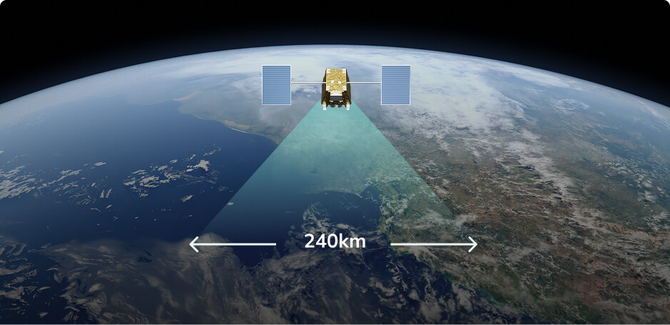
The 8-bit configuration significantly reduces data volumes, enabling rapid processing of the vast areas typical in maritime operations. For vessel detection, anomaly identification, and coastal change analysis, 8-bit depth provides excellent detection capability while optimizing processing speed and storage efficiency.
At 5-meter resolution, Maritime can detect vessels and vessel wakes across open ocean and coastal areas. Detection capability depends on vessel size, sea state, and viewing conditions. Maritime is particularly effective for detecting activity pattern changes and vessel clustering anomalies.
Daily imaging enables pattern-of-life baseline development and behavioral anomaly detection. Persistent coverage reveals deviations from normal patterns that periodic surveillance misses—and eliminates the predictable gaps that adversaries exploit.
Yes. Maritime includes access to the expanding EarthDaily archive, enabling development of historical baselines essential for effective change detection and pattern-of-life analysis.
Maritime is delivered through cloud-native infrastructure via API access, supporting GeoTIFF and Cloud Optimized GeoTIFF formats, STAC-compliant cataloging, and Python client library integration. Data streams directly into existing detection and analytics pipelines.
Yes. Maritime can be combined with Science or AiRD for applications requiring additional spectral bands or higher radiometric depth in specific areas. Many users employ Maritime for wide-area change detection while using other products for detailed analysis.
Maritime delivers near-real-time imagery with rapid processing pipelines designed for operational maritime workflows. Contact EarthDaily to discuss latency requirements for time-critical applications.

Access Detection-Optimized Maritime Imagery

Power your maritime change detection with satellite data built for operational scale. Explore how Maritime delivers the efficient, consistent imagery your detection workflows demand:

  • Access sample data through EarthPlatform to evaluate quality and integration
  • Explore spectral coverage across your application's critical wavelengths
  • Test API integration with the earthdaily-python-client and your existing workflows
  • Configure coverage tailored to your areas of operational interest