.jpg?width=289&height=168&name=Data%20Use%20cases%20(1).jpg)

Every day between a fire and the start of salvage operations is lost value. Burned timber deteriorates, access windows narrow, and competitors with faster data make first contact with government permitting agencies.
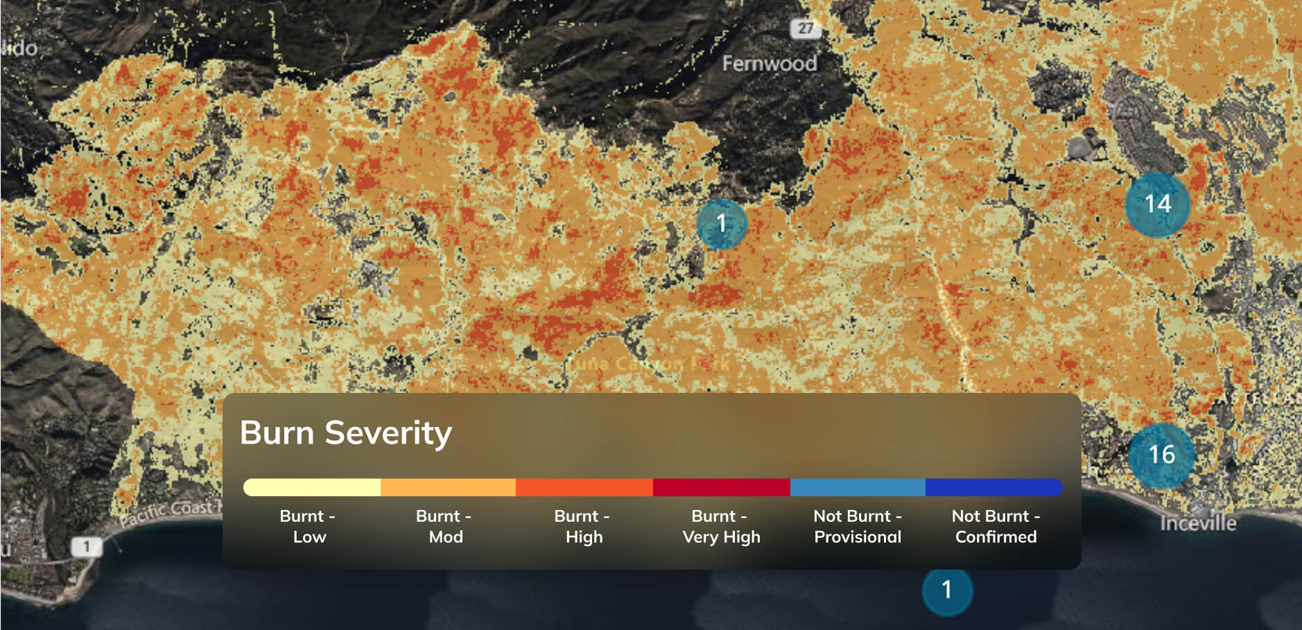
EarthDaily's Burn Severity Mapping uses time-series satellite analysis to produce accurate burn severity maps while fires are still active. You get block-by-block severity classification at 30m resolution, enabling your team to target desirable timber, avoid severely burnt stands, and begin operational planning as soon as it is safe to do so.
Burn severity data is delivered at 30m pixel resolution. Each pixel is classified across six classes from not burnt to high burn severity. Classes can be adapted to meet specific customer requirements.
Satellite imagery is processed during fires using time-series analysis, so severity maps are available while events are still unfolding rather than weeks after containment.
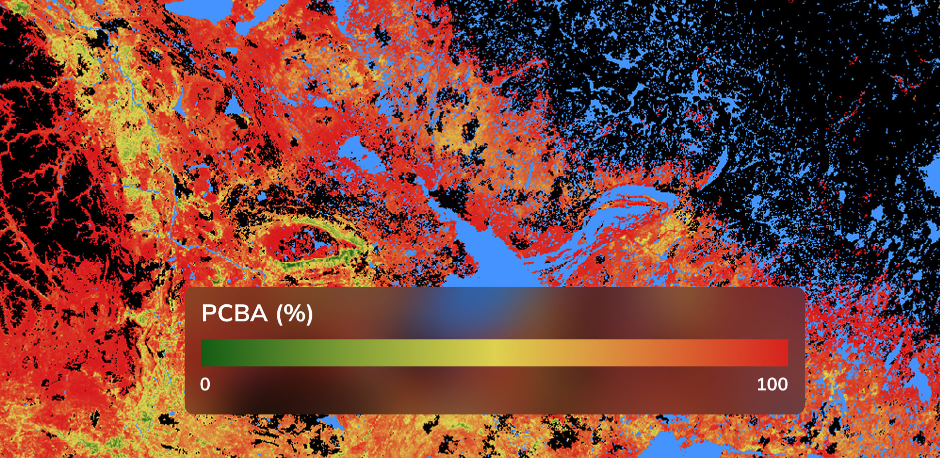
EarthDaily has produced cross-Canada raster layers of Percent Conifer Basal Area at 20m resolution. PCBA data classifies hardwood and softwood composition, enabling salvage operations to target by species group. This is particularly useful when existing forest inventory data is unavailable, outdated, or in doubt.
"The timely access to this information was crucial to a successful operational plan."
— Woodlands Manager
"A consistent tool for reporting to Government on block-by-block burn severity."
— Planning & Permitting Supervisor
Challenge:
A forestry operator managing tenure in British Columbia faces a large-scale wildfire that has burned across thousands of hectares of mixed-species forest. Government reporting deadlines require block-by-block severity documentation, but ground assessment teams cannot access the burn area safely for weeks. Without early severity data, the operator risks losing the window for high-value salvage to competitors with faster planning cycles.
Solution:
EarthDaily delivers burn severity maps at 10m resolution while the fire is still active. The planning team overlays severity classification against PCBA data to identify blocks with desirable softwood composition and moderate burn severity, the stands most likely to yield commercially viable timber. Canopy height data further refines targeting to prioritize taller, higher-value stands.
Outcome:
The operator submits a block-by-block severity report to government ahead of competitors, securing permitting priority for the highest-value salvage areas. Field crews are deployed to pre-identified targets as soon as access is safe, reducing the time between fire containment and salvage operations. Severely burned blocks with low recovery value are deprioritized, focusing equipment and crew time where the return is highest.
Satellite imagery is processed during active fires using time-series analysis. Maps can be produced while fires are still burning, enabling salvage planning to begin before full containment.
Each 10m pixel is classified on a scale from not burnt (0) to high burn severity (6), based on satellite-detected changes in vegetation and ground condition. Classes can be adapted to customer-specific needs, such as consolidating into fewer categories for simplified operational planning.
Ground-truthing by forestry customers has confirmed the severity classification aligns well with field observations for salvage planning purposes.
Data is delivered in GeoTIFF and georeferenced PDF formats. EarthDaily's PCBA layers are particularly useful when existing forest inventory data is unavailable, outdated, or in doubt.
EarthDaily has produced cross-Canada PCBA raster layers at 20m resolution.