Real-Time Crop Market Intelligence In agricultural markets, decisions are often made with limited visibility on supply. EarthDaily closes that gap. Our satellite-driven insights reveal the real standing crop situation in near real time, helping traders, exporters, and grain marketers better anticipate supply dynamics, manage exposure, and act with confidence.
Originators and Merchandisers can adjust procurement strategies in real time, secure supply at optimal pricing, and reduce exposure to market volatility by analyzing:
A reactive approach is no longer sufficient—origination teams must leverage predictive analytics to secure supply ahead of price shifts and disruptions.
Agricultural supply chains are increasingly complex, influenced by extreme weather events, geopolitical instability, and shifting market demand.
Unbiased data? Rumors move the markets, we provide an anchor in reality
Challenge: Commodity prices are influenced by a dynamic interplay of production forecasts, export policies, speculative trading, and geopolitical events. Relying on lagging reports and outdated market intelligence increases risk and limits profitability.
Solution: EarthDaily’s AI-powered analytics track crop health and production trends across major global growing regions, combining:
Agricultural insights from satellite imagery,
Historical yield models to identify analogue years, and
Weather analytics for more precise forecasting.
This enables traders to become more robust to market fluctuations , helping them optimize futures positions and execute trades with greater accuracy, make decisions in confidence.
Use Case: Addressing Real-World Challenges in Commodities Trading
Challenge
A grain merchandising company needs to accurately assess production in their marketing area while staying ahead of competitors in securing supply. Traditional market reports provide lagging indicators, limiting their ability to make proactive purchasing decisions.
Solution
By integrating EarthDaily’s insights, the merchandiser gains:
Real-time visibility into crop conditions within their procurement radius,
Advanced vegetation indices and yield modelling for instant production assessments, and
Standing crop acreage updates and yield estimates to assess potential production.
Outcome:
Dynamic Pricing Advantage Adjusts bid prices ahead of competitors. Respond instantly to changes in yield potential, maintaining strategic and profitable buying decisions.
Early Access to Premium Supply Secures high-quality grain before demand spikes by identifying early acreage estimates and yield variability across farms.
Data Independence & Market Transparency separate the wheat from the chaff, eliminate anecdata by adopting objective, satellite-derived intelligence.
We combine high-resolution satellite-derived analytics with AI-powered forecasts, providing real-time visibility into global and local crop conditions. Continuous satellite monitoring, historical data, and predictive intelligence help you optimize origination, improve trade strategies, and make confident market decisions.
Use Case: Conquer Global Markets: Secure Your Export Edge
Challenge:
A Canadian wheat exporter must track domestic production while monitoring competing exporters like Russia and Argentina. Relying on fragmented reports and outdated production estimates leaves him vulnerable to price swings and shifting trade flows.
Solution: EarthDaily Agro provides:
Satellite-based production monitoring to assess regional crop health and yield potential in Canada and competitor markets,
Historical benchmarking tools to identify analogue years for comparative forecasting, and
Continuous in-season updates for real-time production intelligence.
Outcome:
Adjusts pricing and sales strategies early,
Gains a data-backed advantage in global grain markets, and
Secures more profitable trade contracts.
Case Study Powering Fast-Paced, Proactive Decision- Making For Ag Trader
An agricultural commodity trader relies on EarthDaily’s agriculture platform satellite imaging, geospatial analytics and expert service, to monitor and forecast global crop production, take strategic action and stay ahead of the competition.
Unlock Trading Power: Data Insights, Real Market Advantage
Challenge: A trader managing global corn positions must quickly identify supply risks to optimize futures positions. Manually compiling weather reports, satellite imagery, and trade data is slow and inefficient.
High-resolution crop monitoring for real-time yield tracking
Risk alerts for extreme weather events and production disruptions
Predictive analytics to model potential price shifts based on current conditions.
Outcome:
Anticipates supply disruptions before they impact markets, and
Increases profitability by positioning ahead of price movements.
Informed trades within minutes instead of hours,
Advanced Analytics for Smarter Decision-Making EarthDaily’s Agriculture intelligence platform delivers:
Comprehensive Weather Analytics
Access precipitation, temperature, soil moisture, GDD, ETP,wind speed, humidity, and solar radiation data at field level, with historical archives and forecasts.
Vegetation Index Monitoring
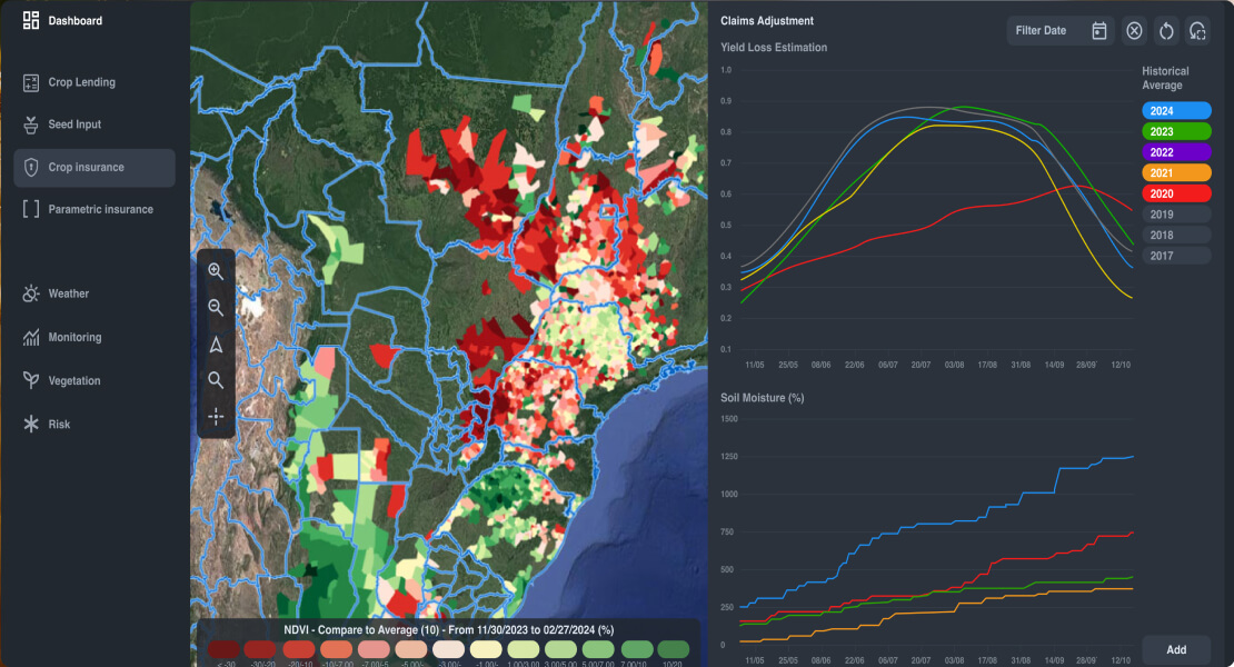
Track crop health using NDVI, LAI, EVI, CVI, GNDVI, and other indices with time series curves, maps, and benchmarking against historical performance.
Parametric Data Exports
Extract precipitation, temperature, and GDD time series or index occurrence data formatted for parametric product development and trigger validation.
Field-Level Benchmarking
Compare individual field performance against regional averages with trending vegetation curves that identify underperforming areas across portfolios.
Flexible API Integration
Access 50+ analytic products through analysis-ready APIs. Execute spatial queries across field boundary collections with crop type and sowing date parameters. Export in multiple formats.
Automated Alerts & Notifications
Configure threshold-based notifications for weather events, vegetation anomalies, or phenological stages across monitored fields.
Take the Next Step
Make smarter, faster, and more profitable trading decisions with EarthDaily.
.jpg?width=289&height=168&name=Data%20Use%20cases%20(1).jpg)


.png?width=1736&height=976&name=yield-potential-agriculture-earthdaily%20(1).png)