Nightshade Mining change detection Detect and track mining activity, in any environment.
Nightshade is a multi-sensor change detection platform purpose-built to identify and monitor mining activity from space. By fusing radar and optical Earth Observation data, Nightshade delivers automated change detection that holds up across cloud cover, dense vegetation, and arid terrain. Move from periodic, single-sensor monitoring to continuous, multi-sensor detection, with the confidence to act on every change.
A change detection built for mining.
Purpose-built for mining oversight, operations, and intelligence, Nightshade combines radar and optical satellite data with environment-tuned detection methods to surface mining-related change wherever it occurs. The platform serves governments tracking unlicensed activity, operators monitoring concessions, and analysts assessing environmental and financial exposure.
Multi-sensor detection that sees through clouds.
Nightshade fuses Synthetic Aperture Radar (SAR) and optical satellite data so detection continues regardless of weather or atmospheric conditions. Radar penetrates cloud cover, smoke, and tropical haze. Optical confirms surface changes when conditions allow. Together they produce a more reliable signal than either sensor alone.
Environment-tuned detection methods.
Different terrains require different detection approaches. Nightshade applies coherence change detection, amplitude change detection, optical change detection, and Bayesian backscatter analysis, each matched to the environments they best resolve. The result is dependable detection in arid deserts, tropical forests, and everywhere in between.
Automated change vectors, validated against ground truth.
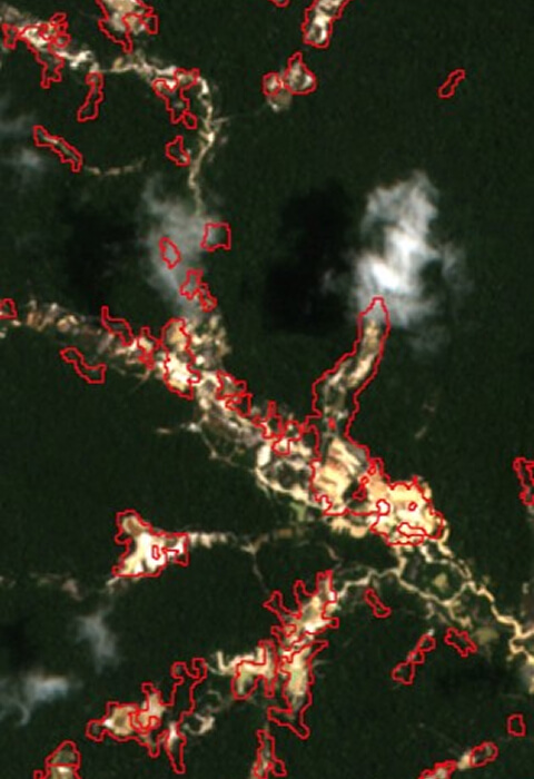
Detections are delivered as date-stamped vector polygons, ready to drop into any GIS or analytics workflow. Triangulation against survey data and open mapping references confirms the underlying detection methodology.
Who benefits
Six teams, one detection layer.
Government & Regulatory
Authorities and ministries.
Detect unlicensed mining activity, monitor permitted operations against approved boundaries, and quantify environmental impact for enforcement and royalty collection.
Defense & Intelligence
National-security agencies.
Monitor strategic resource extraction, track activity in remote and contested terrain, and support sanctions and conflict-mineral oversight.
Mining Operators
Concession holders.
Monitor concessions for unauthorized activity, verify operational footprints, and document environmental performance for stakeholders and regulators.
ESG
Sustainability Teams.
Track deforestation, water impact, and land disturbance associated with mining investments and supply chain exposure
Finance & Insurance
Capital providers.
Independently verify the environmental footprint of mining-related credit, insurance, and investment portfolios
ENVIRONMENTAL NGOS
Monitoring organizations.
Provide independent, defensible evidence of mining activity and its environmental consequences for advocacy, policy, and litigation support.
Core Capabilities Multi-Sensor Earth Data to Mining-Specific Detection
Nightshade combines radar and optical change detection with machine learning, configured for the specific environment of each area of interest. Each sensor contributes a different view of activity on the ground, and ML fusion combines them into a single, more confident output.
Radar Change Detection
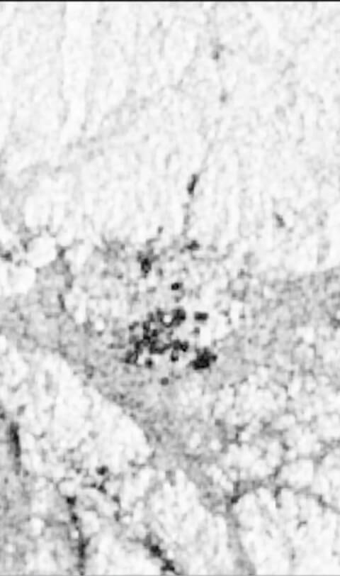
Radar measures the structure and reflectivity of the surface. It detects ground disturbance, the appearance of equipment and structures, and shifts in surface character that indicate activity, regardless of cloud cover, smoke, or seasonal weather. Different radar analysis approaches are applied based on what each environment reveals most clearly.
SAR Amplitude Change Detection
Amplitude measures the brightness of radar signals reflected from the surface. New buildings, vehicles, and heavy equipment reflect more radar energy and appear as bright signatures. ACD highlights the appearance of infrastructure and machinery associated with active operations.
Signal Fusion
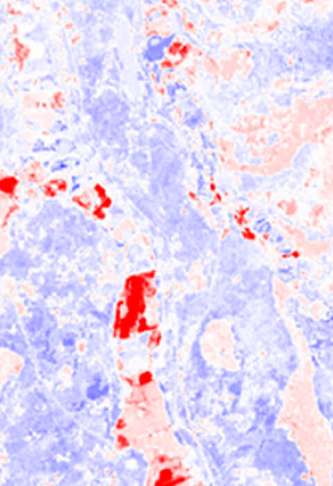
Detections from multiple methods are combined through machine learning models that weight each signal based on environment, season, and historical performance. Fusion reduces false positives and false negatives compared with any single method, and the system improves as it processes more areas and conditions.
Environment-Specific Configuration
Detection parameters are tuned to the environment of each area of interest. The EarthDaily team works with customers to scope detection programs and refine performance over time.
Detect change. Confirm activity. Track it over time.
Year-on-year detection polygons enable trend analysis and separate persistent activity from new disturbance. Multi-temporal heatmaps aggregate detection density across time periods distinguishing continued operations from transient change at a glance.
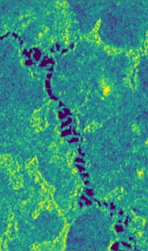
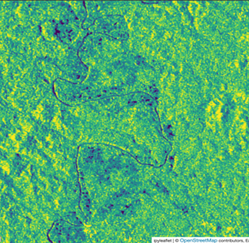
Coherence change detection method identifies ground disturbances that decouple consecutive Sentinel-1 SAR collections
Coverage & scope Global detection, tuned by environment.
Nightshade operates across any geography with available Earth Observation coverage. Detection methods are matched to the dominant environment to maximize confidence.
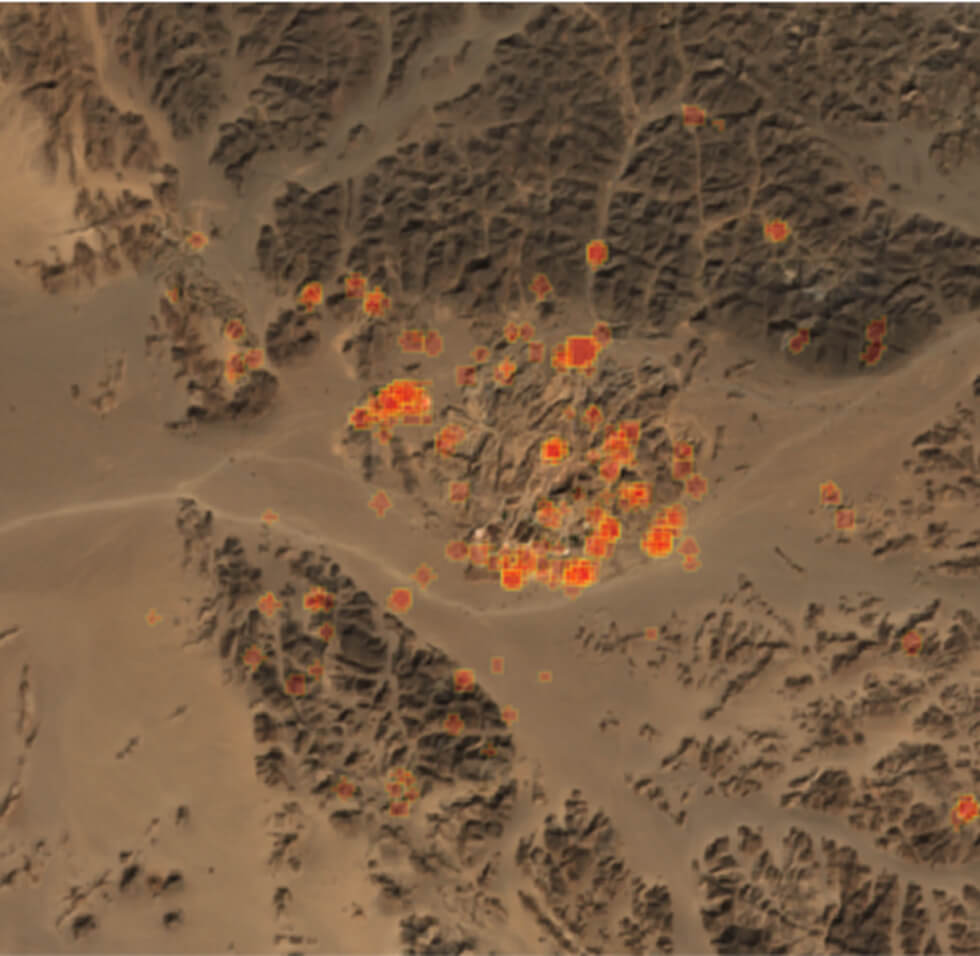
Arid & semi-arid regions
Coherence and amplitude change detection perform strongly where vegetation is sparse. Ground disturbance, vehicle tracks, and structure appearance produce clear radar signatures.
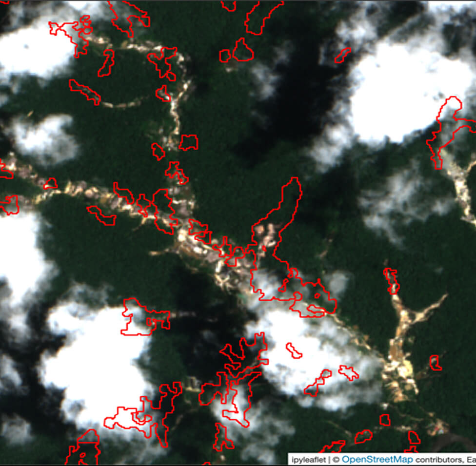
Vegetated & tropical regions
Bayesian backscatter and optical methods combine to detect activity beneath and around canopy. SAR maintains coverage during wet seasons when cloud cover blocks optical sensors.
Coastal, riverine & wetland areas
Multi-sensor monitoring tracks both terrestrial and aquatic change, supporting detection of riverine artisanal mining, tailings releases, and waterway disturbance.
Nightshade features & capabilities Detect change. Confirm activity. Track over time.
01
Ground disturbance detection
Identify excavation, clearing, and earthwork associated with new or expanding mining footprints.
02
Operational footprint detection
Track the growth and change of operational footprints, access routes, and cleared areas associated with active or expanding operations.
03
Vegetation change monitoring
Track deforestation and vegetation loss in and around mining footprints, including encroachment beyond authorized boundaries.
04
Surface water change detection
Monitor changes in water presence, including tailings ponds, pit lakes, and disturbed drainage patterns.
05
Automated change vectors
All detections delivered as date-stamped vector polygons ready for direct integration into operational workflows.
06
Multi-temporal heatmaps
Aggregate detection density across time periods to distinguish persistent activity from transient change.
07
Cloud-resilient monitoring
SAR-based methods maintain detection through persistent cloud cover, wet seasons, and atmospheric interference.
08
Historical baseline comparison
Compare current activity against multi-year baselines to separate new disturbance from pre-existing operations.
09
Customer-informed review
Customers provide local knowledge, field observations, and operational context to help interpret detections and refine monitoring priorities.
10
Configurable detection methods
Match detection approach to environment and operational goal, with multiple methods available for different terrains and conditions.
11
Method refinement over time
Detection parameters and workflows can be adjusted over time as customer priorities, terrain conditions, and monitoring goals evolve. No retraining required.
Vector detection polygons with timestamps, multi-temporal heatmaps, before / after imagery composites.
Detection Targets
Ground disturbance, infrastructure footprints, vegetation change, surface water change.
Methodology Validation
Detections reviewed against open mapping references (OpenStreetMap) and customer-supplied site knowledge.
Update Cadence
Aligned to source satellite revisit cycles.
Scope a detection programme for your areas of interest.
Contact the EarthDaily team to scope a Nightshade pilot sized to your environment, satellite cadence, and operational requirements.
Map your areas of interest and select detection methods for each environment
Define the historical baseline window for time-series comparison
Receive date-stamped vector detections ready to drop into your GIS workflow
Iterate on accuracy with operational feedback from your team
What environments does Nightshade work in?
Nightshade operates across any environment with available Earth Observation coverage. Detection is tuned for the dominant terrain. Radar carries most of the signal in arid and semi-arid regions where vegetation is sparse, while a combination of radar and optical methods is needed in tropical and vegetated environments where canopy obscures the surface. Coastal, riverine, and wetland areas use multi-sensor approaches that capture both terrestrial and aquatic change.
How does Nightshade handle cloud cover and seasonal weather?
SAR-based detection is not affected by cloud cover, smoke, or haze. This matters most in tropical regions where optical sensors alone leave significant gaps during wet seasons. Optical detection adds detail where conditions allow, working alongside radar to corroborate findings.
What types of mining activity can Nightshade detect?
Nightshade is designed to detect ground disturbance from digging and excavation, the appearance of heavy equipment and structures, vegetation loss associated with land clearing, and changes in surface water presence including tailings ponds and pit lakes.
How are detections delivered?
Detections are delivered as date-stamped vector polygons suitable for ingestion into GIS, BI, or analytics platforms. Time-series detection histories support trend analysis and identification of persistent versus transient activity.
What satellite data does Nightshade use?
Current detections combine Sentinel-1 C-Band SAR (10 m resolution, 6 to 12 day revisit) with Sentinel-2 optical imagery (10 m resolution, 5 day revisit). EarthDaily Constellation data extends detection with high resolution satellite imagery and daily revisit.
How accurate is Nightshade?
Multi-sensor fusion combined with ML signal weighting reduces both false positives and false negatives by corroborating detections across independent data sources. Where customers can provide ground truth, field observations, or other reference data, detection parameters can be tuned and performance improved over the lifetime of a program.
Can Nightshade distinguish between legal and illegal mining activity?
Nightshade detects mining-related change. Determining whether that activity is licensed requires overlay with concession boundaries, permits, and other authoritative datasets. Users combine Nightshade outputs with their own permitting data to flag activity outside authorized footprints.
Can Nightshade monitor specific sites or large regions?
Both. Detection runs at any scale, from single concessions to entire mineral provinces or national territories. Coverage area and update cadence are matched to operational requirements.
How is Nightshade configured for a specific use case?
Detection methods, area of interest, baseline period, and alert thresholds are configurable to match environment and operational goals. [VERIFY: whether configuration is self-serve, supported, or fully managed]
How does Nightshade integrate with existing systems?
Vector outputs work directly with standard GIS tools and analytics platforms. [VERIFY: API availability, supported formats, integration documentation]
.jpg?width=289&height=168&name=Data%20Use%20cases%20(1).jpg)


.png?width=842&height=724&name=Nightshade-2%20(1).png)
.png?width=840&height=724&name=Nightshade-1%20(1).png)
