

.jpg?width=289&height=168&name=Data%20Use%20cases%20(1).jpg)
Before launch
Tunable lasers
Detector responsivity was characterised with tunable lasers, establishing the response of each element across its band before the instrument ever saw daylight.
Technical specification
Calibration, the comparison against other mission classes, and what the constellation adds over time. Every figure here is from the EDC product specification v1.0.
Calibration and validation
Detectors drift. Optics shift on launch. If that goes unmeasured, a slow instrument change looks exactly like slow change on the ground, and the archive quietly stops being comparable. Calibration is therefore continuous, and it is tied to missions the science community already trusts.
Before launch
Detector responsivity was characterised with tunable lasers, establishing the response of each element across its band before the instrument ever saw daylight.
In orbit, continuously
Geometric sites carry well-distributed features that resolve interior orientation, meaning optical distortion, and exterior orientation, meaning camera alignment. Radiometric and atmospheric sites support vicarious calibration, trending and imager-to-imager alignment.
Across the mission
Measurements are cross-calibrated against science-grade missions at those sites. The geometric reference is derived from Sentinel-2 and Landsat scenes, which is how absolute geolocation, inter-satellite alignment and co-registration are held together.
Payload
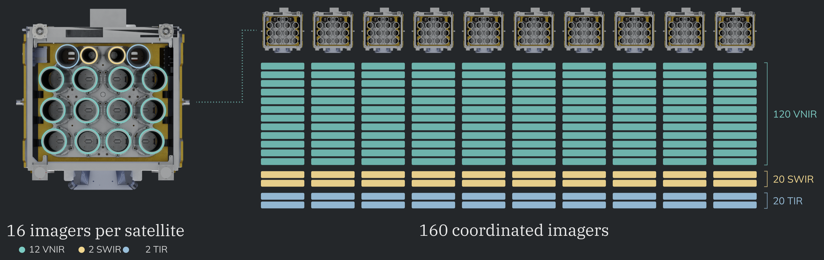
Sixteen imagers on each satellite look through the same optical bench at the same moment, and every satellite is held to the same viewing geometry and the same calibration. That is what lets a measurement from one imager be compared against a measurement from another.
22
Calibrated bands
Eleven visible and near infrared at 5 m, six shortwave at 95 m, five thermal at 120 m.
240 km
Swath per pass
Identical for the VNIR, SWIR and TIR band groups.
608 km
Orbit altitude
Sun-synchronous at 97.7 degrees, crossing the equator at 10:15 and 10:45 local.
Under 12°
Across-track viewing
Nadir imaging, so successive days line up without resampling.
How the choices compare
Three classes of optical mission exist today, and each gives something up. Commercial high-resolution fleets buy detail and pay in coverage and consistency. Public science missions buy consistency and pay in revisit. EarthDaily was specified to hold measurement quality and daily systematic coverage at the same time.
| Feature | EarthDaily | Typical CubeSat constellations | Why it matters |
|---|---|---|---|
| What we collect | |||
| Measurement quality | Sharp | Noisy | Ensures detected changes reflect true ground transformations rather than sensor or atmospheric noise. |
| Swath | 240 km | 24 to 32 km | Expands coverage per pass to monitor regional changes more frequently. |
| Spectral stack | 22 calibrated: 11 VNIR, 6 SWIR, 5 TIR | 4 to 8 | Aligns pixels under identical atmospheric conditions for accurate detection of subtle surface changes. |
| Pixel size | 5 m | 3 to 4 m | Slightly lower pixel size improves the SNR, and allows for wider swath. |
| Radiometry | 16-bit depth | Lower depth, variable | Consistent collection times ensures color accuracy for effective detection. |
| Geolocation | Aligned | Misaligned | Analyze exact image overlays for greater accuracy. |
| How we collect | |||
| Orbit | All satellites are in the same sun-synchronous orbit, crossing the equator at 10:15 and 10:45 local | Multiple orbits, inconsistent crossing times | Consistent geometry and radiometrics. |
| Angle | Nadir | Varied, non-nadir | Nadir viewing eliminates geometric distortion, ensuring algorithms compare real surface changes rather than off-axis viewing artifacts. |
| Contributing satellites | 9 + 1 in the same orbit (nine operational, one in-orbit spare) | 120+ in different orbits | Risk of masking change increases with more satellites used. |
| Satellite class | Minisat, 200 kg | CubeSat, ≅ 5 kg | Supports superior optics and higher throughput, providing the signal quality and stability critical for accurate broad-area change detection. |
| Satellite mission | 10 yr. avg. | 3 yr. avg. | Disrupts continuity, increasing data variability. |
| When we collect | |||
| Revisit rate | 92% of landmass daily | 78% near-daily | Receive more accurate change values. |
| Time of day | Exact: 10:15 and 10:45 local crossing times | Varied | Consistent sunlight provides comparable brightness values. |
| Latency | SLA dependent, priority as quickly as 3 hours | SLA dependent | Flexible delivery options. |
Built to keep adding
The choices above were made for a mission measured in years. Seven bands are already on board ahead of their release, and three further choices only pay out over time.
Already in orbit
Two methane channels and five thermal infrared bands are carried by the imagers now and release at full operations. Adding them requires no new spacecraft and no change to the archive that precedes them.
Compounding
Every day adds imagery collected at the same angle, the same local time and the same calibration as the day before. A consistent decade of history cannot be assembled retroactively from inconsistent collections.
Maintained
The orbit is precisely maintained so the viewing geometry customers depend on does not drift, and a tenth satellite is already in orbit to protect the daily plan.
Automated
EarthPipeline handles cloud detection, atmospheric characterisation and delivery automatically, which is what makes daily global collection usable rather than merely large.
Read the specification
The EDC product specification carries the full band table, product levels, processing chain and quality masks behind the summary above.