EarthMosaics
Imagine being able to go back in time to identify a trend or a pattern shaping and molding our land.
Whether it is an environmental policy, or an infrastructure regulation deployed over a certain period of time, there are impacts to be evaluated, lessons to be learned, and most importantly, risks to be mitigated.
Powered by AWS
Application-specific with customized insights
From analyzing a regional forest to monitoring a mining site, predicting water reservoir levels to measuring melting permafrost, EarthDaily EarthMosaics offers application-specific and customized insights fulfilling unique needs of each use case.
Powered by AWS
Cloud-free, temporally coherent
Our EarthMosaics delivers cloud-free, temporally coherent mosaics with the highest possible geolocation and radiometry quality, enabling users to examine true signals, minimize false positives in change detection, and easily contextualize with other geospatial datasets.
Capability highlights
Radiometric Balancing
Geometric Alignment
Pixel Composition
Data Filter and Selection

Now in Beta
BYOA and Interface Optimization for minimal Total Cost of Ownership (TOC)
Cloud Optimized GeoTIFF (COG) image format and Spatio Temporal Asset Catalog (STAC) metadata format in AWS are suitable for Bring-Your-Own-Algorithms in AWS SageMaker, enabling efficient, seamless integration—perfect for time-sensitive, mission-critical projects.”
Interfaces optimized with the industry’s latests standards and features such as XYZ tile streaming enable GIS technicians to effortlessly pull disparate data sources into ArcMap/QGIS for visual analytics in no time.

Delivering cloud-free high-quality data so you can be ready to respond to any geospatial challenge.
Mapping Big and Small
Mosaic challenges grow exponentially with scale – correcting 10 images can be hard but how about 100 or 10,000+ images?
Our Analytics Ready Mosaics provide maps for you to power large scale applications such as accurate land cover or agriculture classification.
Object and Change Detection
Our Analytics Ready Mosaics are geometrically and radiometrically corrected so you can see the subtle changes in your maps. Detect changes faster than ever before with more ease and fewer false positives.
(Top) A window selected from a refined Sentinel-2 Mosaic.
(Left) Zoomed in window from Spring 2019,
(Center) Magnitude of change between Spring 2019 and Fall 2019
(Right) Identified region of significant change in Fall 2019.
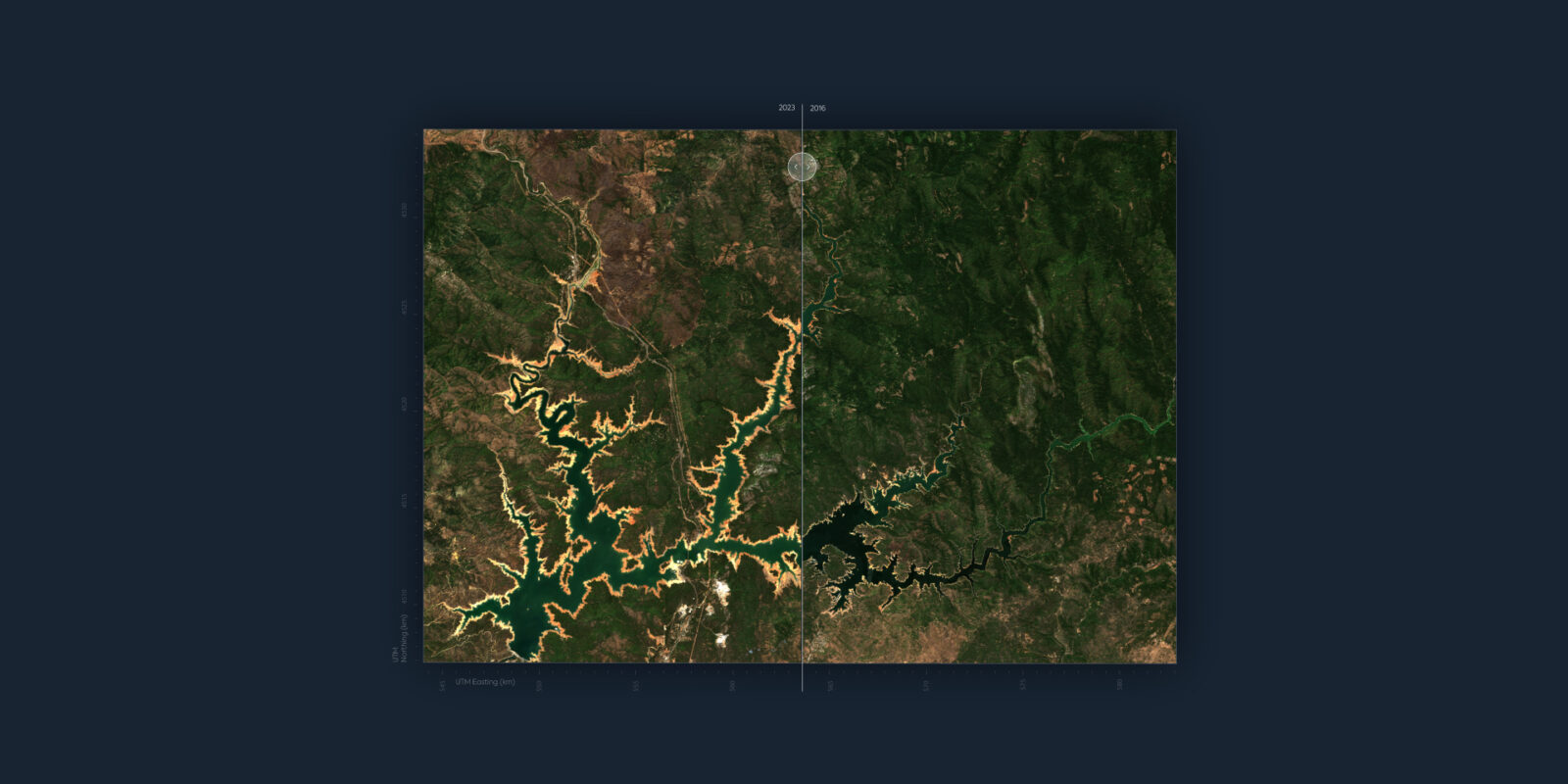
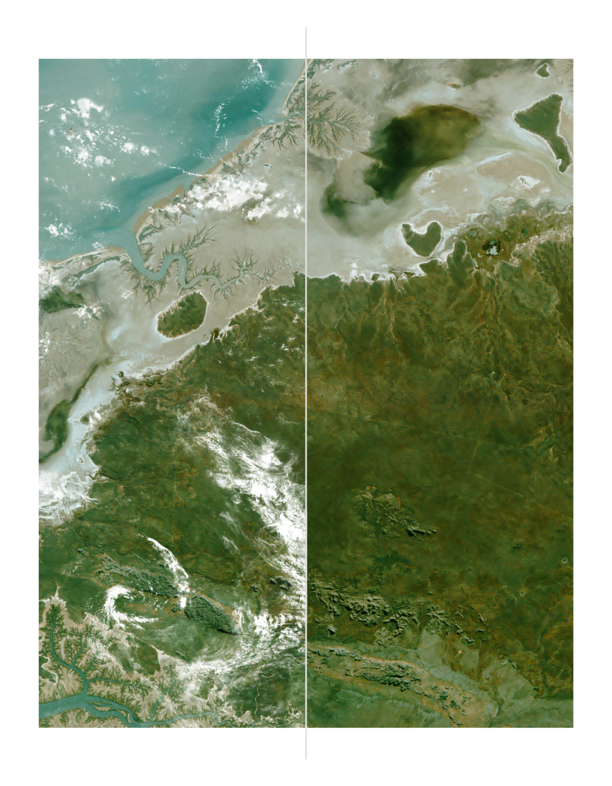
Environmental Change
Natural regions change as new ecosystem variables are introduced, such as mining sites, urban sprawl, pests, and extreme weather events. Seasonal mosaics enable you to measure change over the course of a year or across multiple years.
Exploitation Ready
Web Streaming and Cloud-Optimized GeoTIFFs enable your application to see the scientific signals, minimize false positives in change detection, and makes data contextualizable with other geospatial datasets a breeze.
Get your cloud-free 10m Sentinel-2 mosaics delivered as you need them; from a web interface for visual analytics, as a Cloud Optimized GeoTIFF for analysis, or an XYZ tiled web-streaming service for data exploitation systems.
EarthMosaic Features
EarthMosaicsTM
Other Mosaics
Scalable
Regions of any size.
Limited
Data Provenance
All pixels, tracked to a source.
No
Location Accuracy
Corrections Applied to Mosaic
No
Colour Accurate
Colour Balanced
Some Providers
Time Accurate
Automatic data curation
Manual Data Curation
Quality Masks
Included from Feedstock
No
Quality Assurance
Yes
No
There’s enough data out there, but not enough at the level of accuracy, quality, and coverage we offer
Global change detection at its best is finally a reality.