.jpg?width=289&height=168&name=Data%20Use%20cases%20(1).jpg)
Why Speed and Scale Matter in Generative Exploration
Remote sensing has proven value in early-stage mineral exploration. It empowers exploration teams to screen massive areas of ground, reduce uncertainty, and make better decisions before capital and time is intensely consumed on other probabilistic and deterministic sources of decision-making information.
In our experience, we are seeing significant momentum in the adoption of remote sensing for mineral exploration across the entire mining and exploration stakeholder spectrum. The adoption varies from reliance on specialized consultants for project specific insight, through to operating models being updated to support remote sensing capability development and technology integration. The point is the same; remote sensing is a tool in the toolkit and no longer a software line item in a budget. However, like all things, there is an opportunity for improvement.
What is still holding the remote sensing back from large scale access and democratization is not the data or the science. It is the processing workflow.
Where the Bottleneck Sits
Traditional remote sensing stacks were built for a different time. Data is sourced, pre-processed and uploaded manually and processing happens one job at a time. And while the progress bar inches forward, the decision-making waits, or worse, it is sub-optimal.
At a time when modern mineral exploration is high stakes, largely driven by the global energy transition and the urgent need to secure sustainable and diversified critical mineral supply chains, this friction matters.
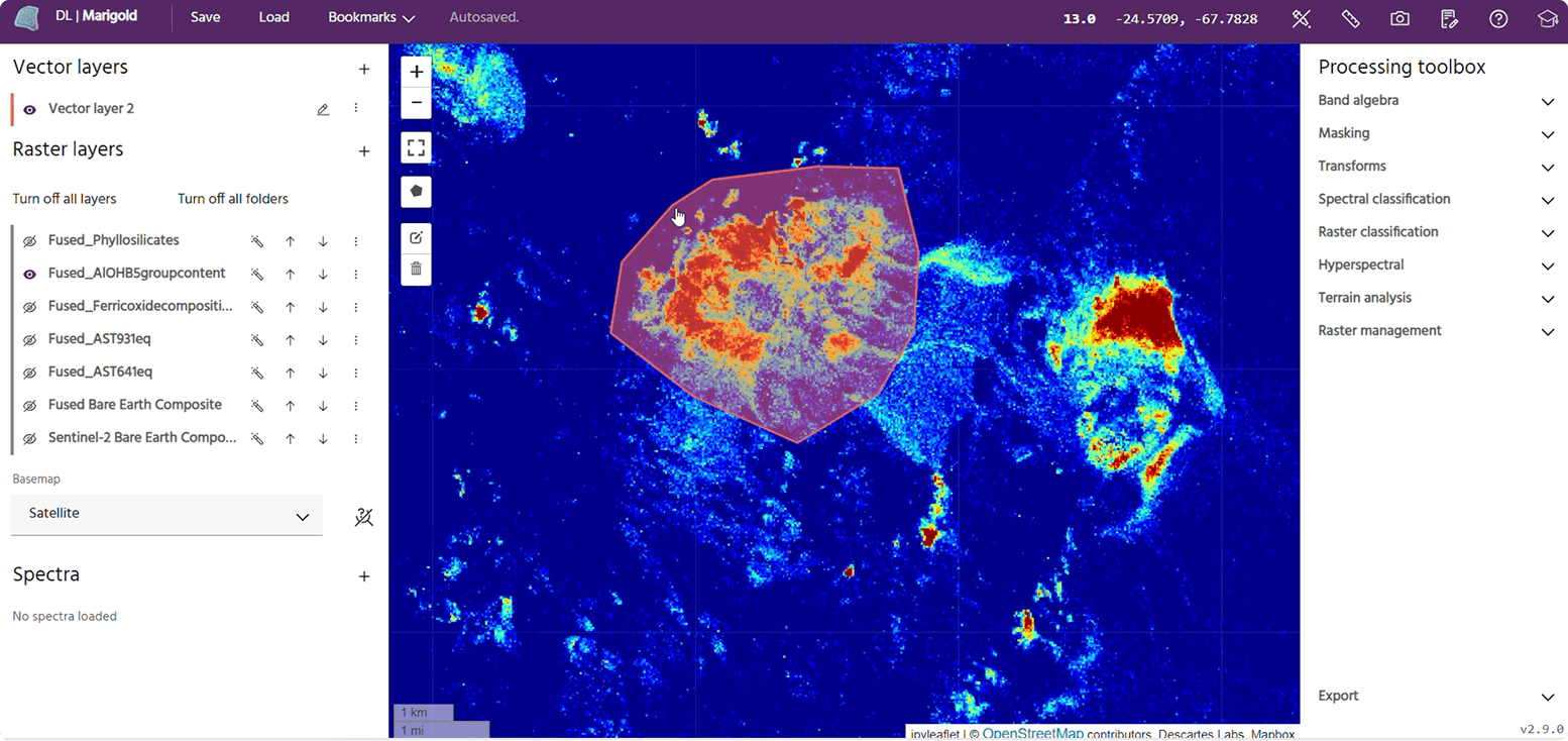
The video accompanying this point of view shows a simple, revealing comparison. Using high-resolution airborne hyperspectral data collected by SpecTIR over Cuprite, Nevada (1 m spatial resolution, 1,024 bands spanning the VNIR–SWIR), we ran the same Spectral Angle Mapper (SAM) classification workflow in both Marigold (right) and ENVI version 6.0 (left).
In ENVI, 85% of a single SAM classification was completed in the time it took Marigold to complete a full mineral mapping workflow consisting of eight SAM classifications, generating binary mineral maps across the entire dataset and making the results ready for interpretation and decision making.
Click to discover more about Marigold
The point here isn’t which tool is ‘better’. ENVI’s capability continues to develop, and we can’t comment on what’s in the works. The intent is to show what happens when regional-to-camp scale processing and interpretation can be done routinely, not selectively, because speed and scale are no longer constraints.
Speed and Scale in Early-Stage Exploration
Remote sensing is most powerful when it is used generatively, early, and iteratively. This means testing hypotheses quickly, discarding sub-optimal ideas early, and prioritizing the targets that best align with the exploration strategy. When data acquisition is arduous, processing is slow and workflows fragmented; exploration geologists become conservative and skeptical. Fewer geological questions, less experimentation, less options, and early-stage value are left on the table.
Marigold is explicitly designed for mineral exploration and has removed these barriers. Multispectral and hyperspectral data sourcing and pre-processing are handled. Processing is not limited by desktop or on-prem compute, and processing tools are structured to reflect how exploration geologists and remote sensing specialists ask questions.
This means Marigold users aren’t waiting; instead they test more hypotheses earlier in the exploration cycle. They ask harder geological questions when optionality still exists. They assess more belts, generate more targets, and can do this with out increasing headcount.
This capability also positively impacts field programs. The mapping and field-spectra results from field work can be turned around quickly, fed back into Marigold, and used to refine what happens next. This tight loop improves field work efficiency and helps capital move with confidents toward subsequent geophysics, geochemistry, and drilling decisions.
In practical terms, Marigold functions as a fast, global sandbox for target generation and refinement. It acts as a force multiplier with more options earlier, enhanced screening and less capital committed before uncertainty is reduced.
For EarthDaily, the opportunity is clear: resource discoveries are down, capital is tighter, and demand for key minerals is shifting fast. Explorers using remote sensing to shorten target generation and reduce uncertainty earlier can iterate faster, focus budgets on the best ground, and improve discovery odds. In today’s mining environment, speed plus confidence is a real advantage.
If you want your exploration workflows to benefit from this, let’s talk.
About the Author