.jpg?width=289&height=168&name=Data%20Use%20cases%20(1).jpg)
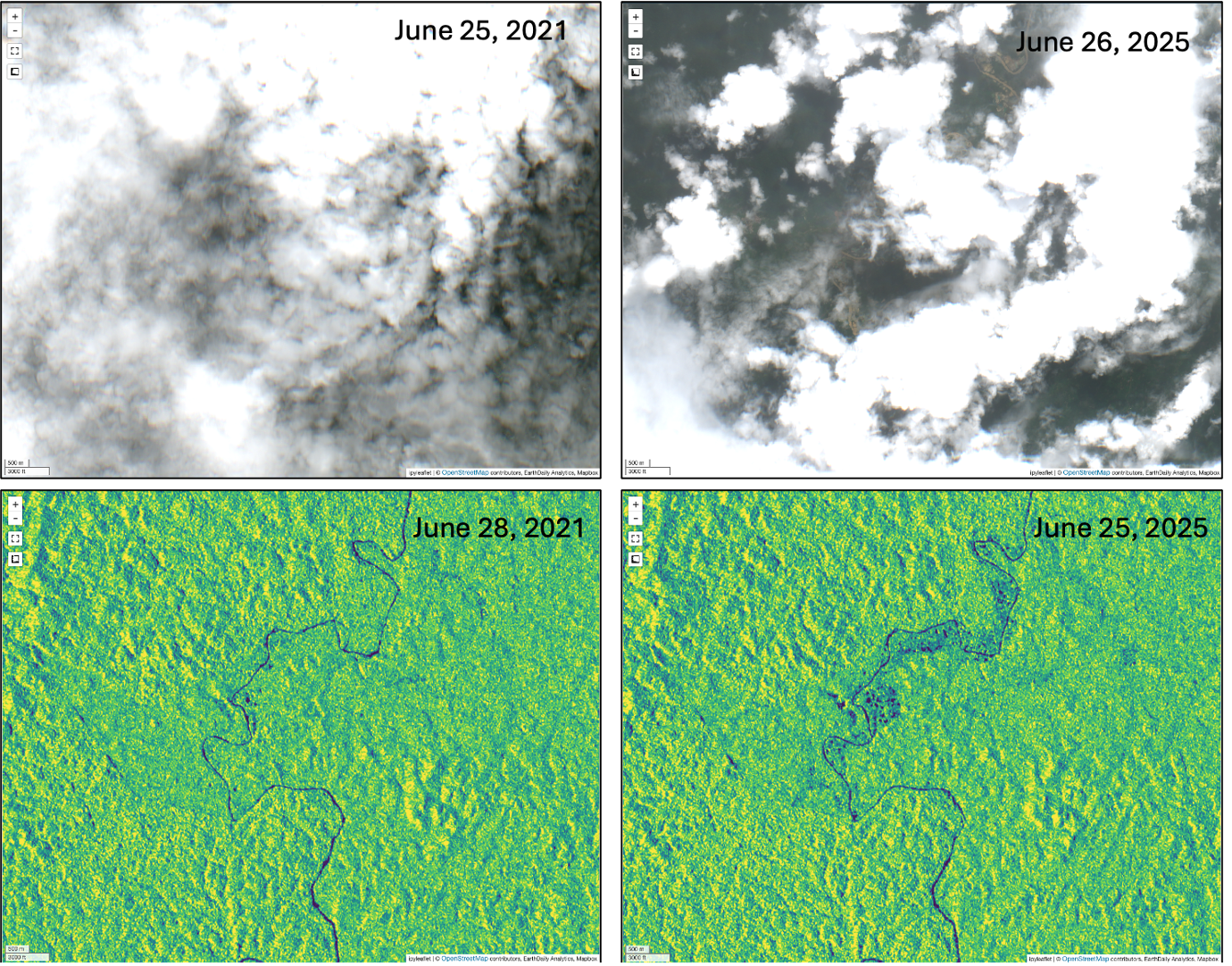
The progression of ASM between June 25, 2021 and June 26, 2025 along a river corridor in Western Africa. The Sentinel 2 optical images captured at the start and end of this monitoring window inhibit ASM signals due to cloud cover. The Sentinel-1 backscatter images are not impacted by cloud and clearly show the growth of ASM activity adjacent to the river over the 4 year monitoring window. Source: EarthDaily Nightshade analysis
As discussed in previous blogs, ASM is hard to monitor. Activity can be scattered across large areas and it can start small, expand quickly, pause, shift location, or move into areas where access is difficult or unsafe. In some places it is formalized and part of the recognized mining economy. In others it is informal, tolerated, disputed, or illegal. Sometimes those categories are clear, but there are times when they are not.
That is why the monitoring problem is not simply, “Can we see ASM activity?” From previous blogs you would have seen satellite images that clearly show the activity and stakeholders currently undertaking monitoring have plenty of data that confirms its presence.
The better question that has been posed throughout this series is, “can we build a reliable record of where surface activity is changing, how it is changing, and where that change matters?”
In the previous article, I wrote about what effective ASM monitoring requires: regional coverage, repeatable observation, all-weather capability, quantifiable change, and enough context to separate useful signal from noise.
This article looks at how EarthDaily’s Nightshade helps deliver that intelligence.
Earth Observation is Necessary, but Interpretation is What Builds Intelligence
Satellite imagery is central to ASM monitoring. There is no practical way to build a consistent regional or national view of ASM activity through field reporting alone. The scale is just too large, the terrain makes access challenging, and the activity can change too quickly.
But it is also important to be transparent about the limits of the various types of Earth observation data.
Optical imagery is powerful, but it does have limitations. Cloud, smoke, haze and nighttime conditions inhibit its effectiveness. Vegetation can inhibit the detection of early disturbance and seasonal change can further confuse the interpretation. Other features and land uses such as surface water, agriculture, roads, construction, and legal mining activity can also create surface changes signals that may look relevant at first glance.
A single satellite image can show disturbance, but disturbance is not automatically ASM. Real ASM intelligence comes from signal confidence and contextual interpretation.
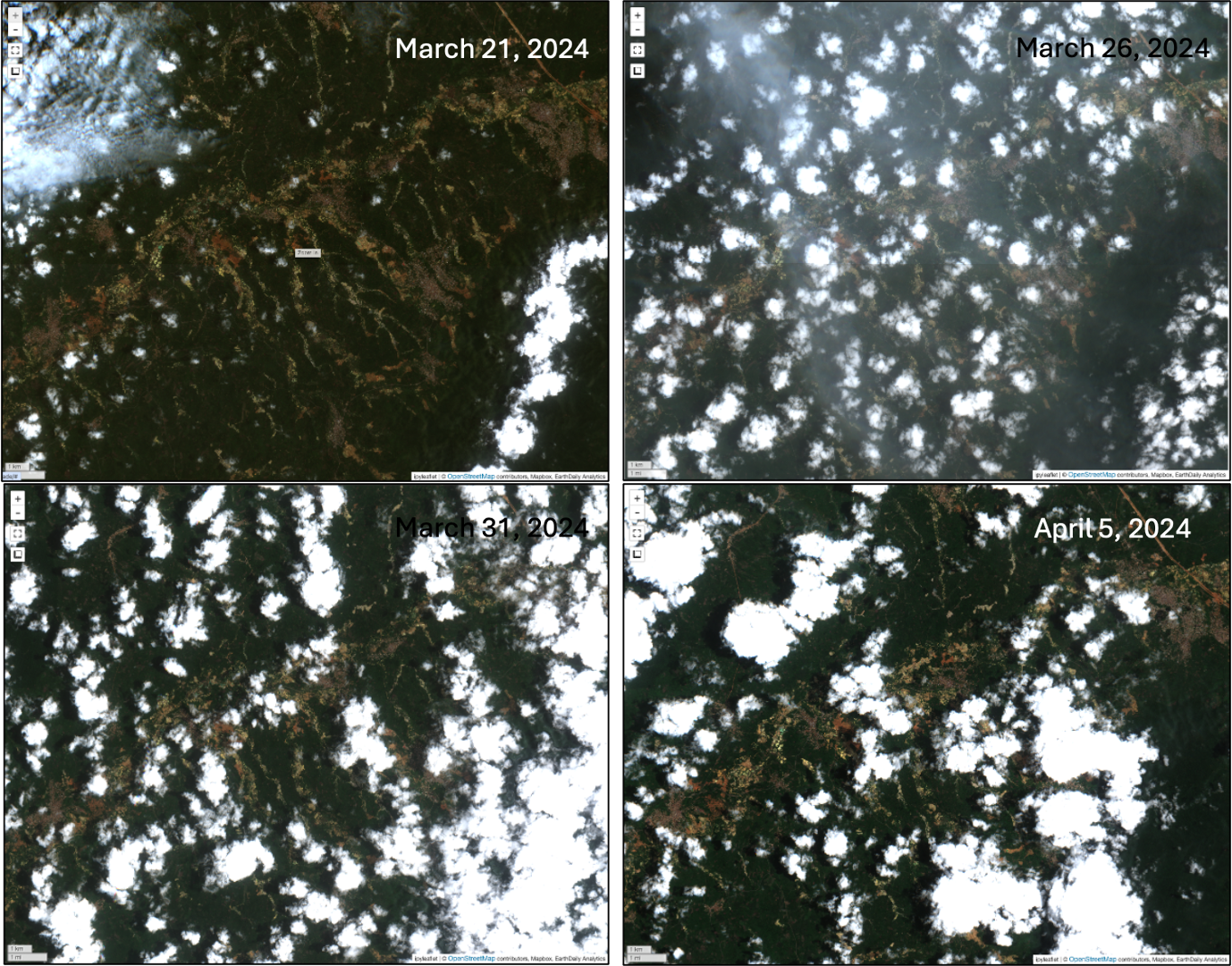 Sentinel-2 imagery collected over an area of West Africa at 5 day revisit frequency between March 21, 2024 and April 5, 2024. Cloud and haze inhibit comprehensive change detection, resulting in wider change detection windows and reactive decision making. Source: EarthDaily Nightshade analysis
This is where Nightshade is valuable. It is not just looking at one image and asking someone to visually inspect it. Nightshade is built to detect change over time, across large areas, using different types of satellite data and repeatable processing methods. This approach to change detection is what enables the generation and maintenance of a systematic record of ASM activity.
The Value of Satellite Radar
A lot of ASM monitoring has historically depended on optical imagery. That makes sense because optical imagery is very intuitive and allows people to look at it and understand what they are seeing.
But optical-only monitoring has weaknesses, especially in cloud-prone, tropical, forested, or wet-season environments. If the ground is covered by cloud at the wrong time, the evidence gap remains. If the change happens between useful collections, it may be missed or only understood at a later time, which fundamentally limits tactical response decision making.
Nightshade addresses this by integrating Synthetic Aperture Radar, or SAR, into the monitoring approach. SAR can collect information through cloud and does not depend on daylight. That does not make it a replacement for optical imagery, but it makes it an important part of a more resilient monitoring system.
In some arid environments, radar coherence can help identify ground disturbance that may be subtle in optical imagery. In other settings, radar backscatter, optical imagery, vegetation indices, water masks, forest masks, and other supporting layers can be combined to help isolate areas where mining-related change may be occurring. The point is that ASM does not occur in one type of landscape, so the monitoring system cannot rely on one type of signal.
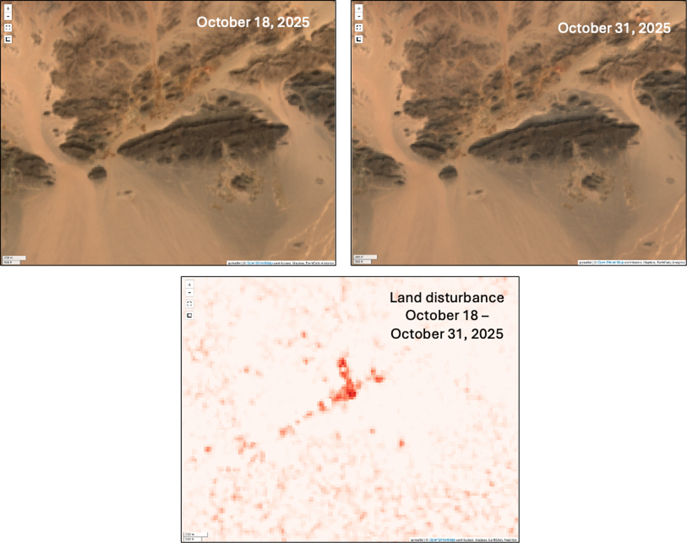 Sentinel-1 radar coherence change, captures ASM activity between October 18 and October 31, 2025 over the Arabian-Nubian Shield. Relying on the Sentinel-2 optical imagery alone limits the ability to detect subtle ground changes associated with ASM. Source: EarthDaily Nightshade analysis
Varying Degrees of Decision Making Require Different Scales of Intelligence
For our end users, ASM monitoring has to work at different scales. A government agency may need a national or regional picture of where activity is expanding. A mining or exploration company may need to understand whether ASM activity is moving toward a property, camp, water source, or future development area. A policy team may need to understand whether a formalisation program is changing behaviour, whereas a field investigations team may need coordinates and mapped areas for investigation follow-up.
Nightshade has been designed to support this range of use. At a broad scale, it can help identify where surface activity is changing across a country, region, or large area of interest. At site scale, it can help focus attention around specific assets, boundaries, river systems, protected areas, communities, or known ASM zones.
This is extremely beneficial because ASM decisions are not made at one scale. The same monitoring capability can support national planning, local engagement, concession risk management, enforcement prioritisation, or field verification.
Signal Plus Context is Intelligence
Nightshade’s role is to detect and deliver signals of surface change. But the signal still has to be interpreted by people who understand the local context and turn it into intelligence.
When interpreting change signals, the context in which that signal has been detected matters greatly. A cluster of small workings inside a designated ASM area may mean something very different from a similar cluster inside a protected area or along a river. Disturbance near a formal mining operation may point to encroachment risk. Similar disturbance in a known community mining area may point to formalisation, economic livelihoods, or regulatory engagement.
Nightshade is agnostic to the type of ASM being monitored because the first job is to identify surface activity and change. Whether that activity is formal, informal, illegal, tolerated, permitted, seasonal, or disputed depends on the operating context.
That interpretation should be done with the end user, not assumed by the technology.
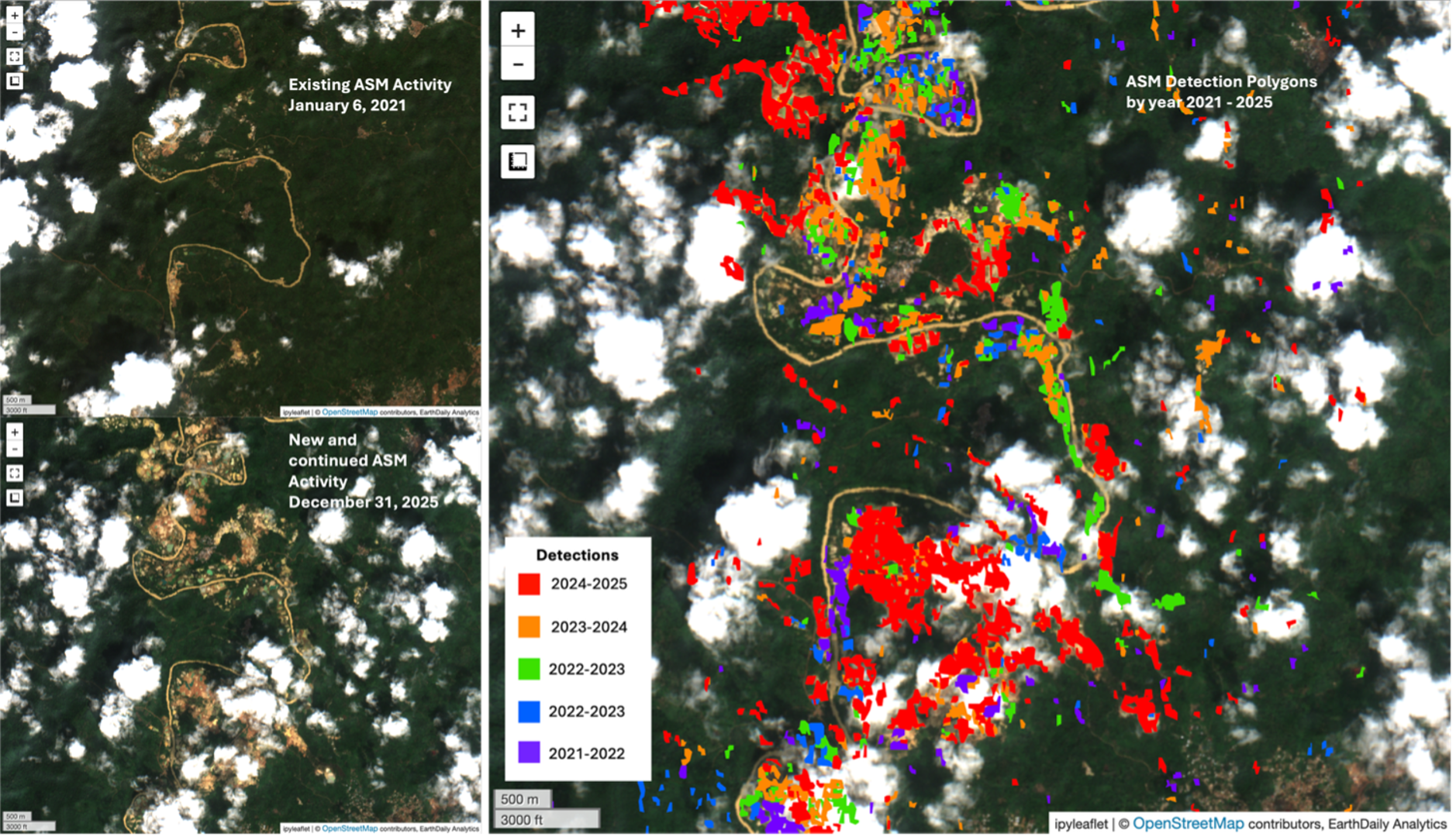 A localized example within a river corridor in West Africa. The images on the left shows Sentinel-2 optical over an area of existing ASM activity as of January 6 and through to December 31, 2025. Optical signals show clear growth in ASM over the 5-year period. The image on the right shows annual detections over Sentinel-2 image. Source: EarthDaily Nightshade analysis
This is an important point as Earth observation can help show what is changing on the ground, but it cannot, by itself, determine legality, intent, ownership, labour conditions, supply chain relationships, or community dynamics. Those require local knowledge, policy context, regulatory data, and often field verification.
Nightshade strengthens that process by giving users a consistent evidence layer to start from and an ongoing change detection system that lends itself to identifying and understanding ASM trends.
Where EarthDaily Constellation Data Fits
As discussed above, Nightshade already uses radar and optical Earth observation to support ASM monitoring. EarthDaily’s own EarthDaily Constellation data will strengthen this further.
Daily medium-resolution optical collection and 22 spectral bands will help improve the consistency and richness of optical monitoring. More frequent collection increases the chance of getting usable observations between clouds. More spectral information can help distinguish surface materials, vegetation, water, exposed ground, and other features that matter when interpreting change.
This will not remove the need for SAR. Radar remains important because cloud, night, and difficult viewing conditions will continue to affect optical data.
The stronger approach is to integrate SAR for continuity with optical data for visual and spectral context, and scalable processing to turn those observations into repeatable monitoring and intelligence building.
What Nightshade Adds to Better Understanding ASM
Nightshade does not solve every ASM monitoring challenge and while satellite imagery is an essential part of a comprehensive monitoring system, it is not a silver bullet. What it actually does is make the ASM activity layer more visible, repeatable, and scalable.
It helps users see where ASM-related activity may be occurring, where it is changing, where it is intensifying, and where it may require follow-up and additional deterministic data. It supports monitoring from national scale down to site level. It also helps build historical baselines and reduces dependence on optical-only observation by integrating SAR. And it delivers outputs that can be used combined with other complimentary and context setting data sets to support richer interpretation and intelligence building.
Most importantly, it gives decision-makers more consistent evidence which is important because ASM decisions are often made with incomplete information. Some of that will always be true. ASM is complex, local, and deeply connected to livelihoods, regulation, security, environment, and mineral supply chains, but better monitoring can reduce the blind spots.
Nightshade provides a practical way to move from scattered observations toward a more continuous record of surface activity, giving current and future ASM management programs and efforts a stronger foundation.
About the Author