.jpg?width=289&height=168&name=Data%20Use%20cases%20(1).jpg)
The traditional "snapshot" era of geospatial intelligence (GEOINT) is over. For decades, the industry was defined by the hunt for the "golden pixel" — the single, high-resolution image capturing a moment in time.
Geospatial intelligence is currently being reshaped by the emergence of persistent global observation. Automated analysis and sovereign control over data pipelines have become foundational elements of modern intelligence, moving the industry toward a model where calibrated daily global monitoring is technically feasible and operational necessity.
The implications of this shift extend well beyond the act of collection. When observation becomes continuous, the very nature of analytical timelines changes. The systems we are deploying today are defining how governments will detect emerging activity, interpret risk, and ultimately act with a new certainty.
At this year’s Defence Geospatial Intelligence (DGI) conference in London, I had the opportunity to discuss these developments with defence and intelligence leaders. Our conversations reflected a shared recognition: the scale, cadence, and application of geospatial intelligence are evolving at a breathtaking pace.
The timing was significant. Only days before the conference, calibrated imagery from EarthDaily’s first satellite, EDC-01, was released. These scenes provided an early, practical illustration of consistent, repeatable observation – delivering high quality data optimized for automated analysis and AI-driven change detection.
The reaction from the community was telling: it was less “I’ll think about it” and more “when can I have it?”
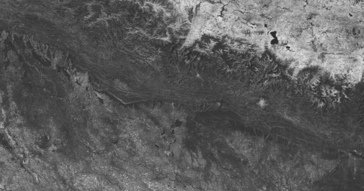
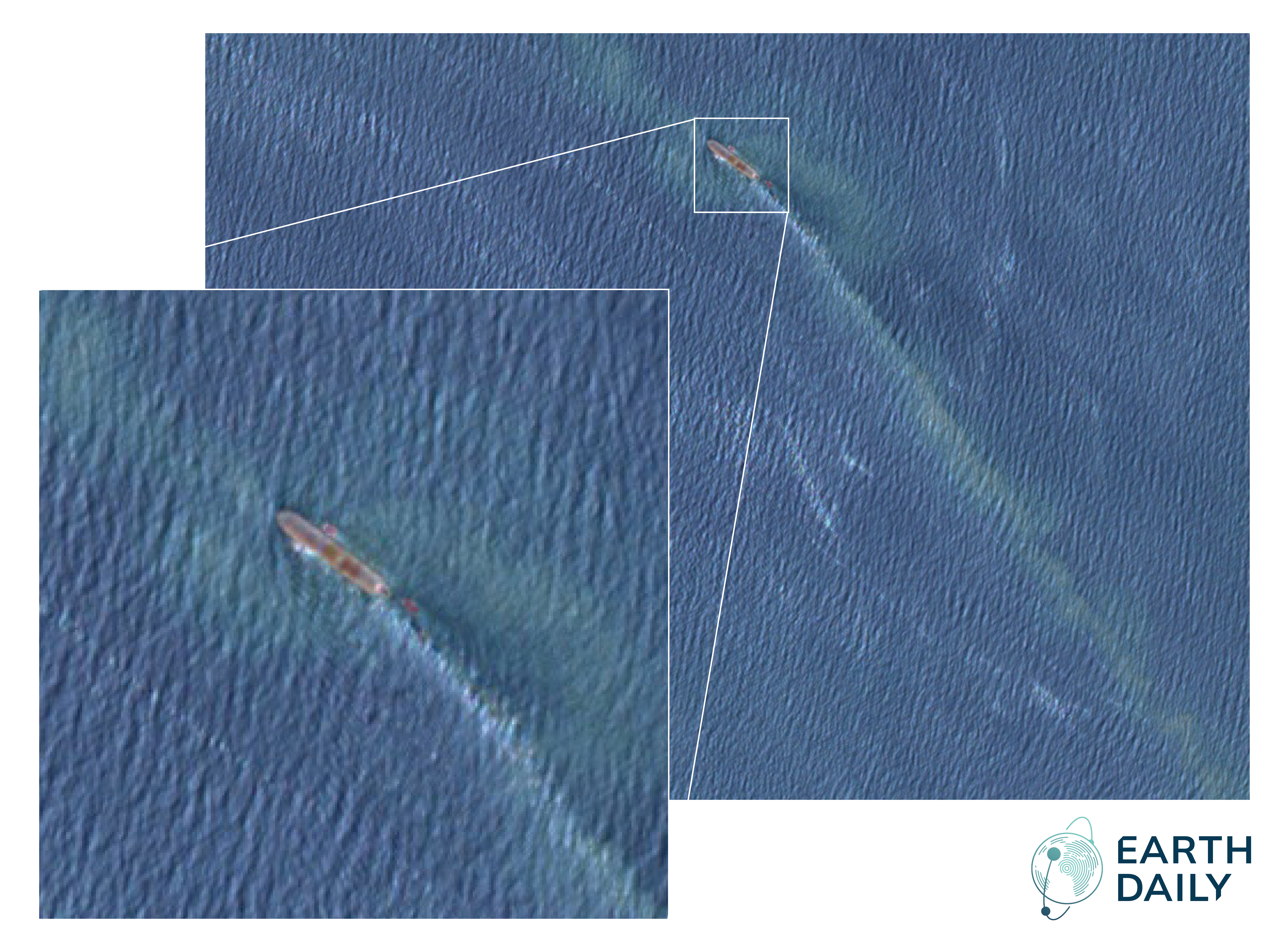
.png?width=1920&height=1080&name=earthdaily-desert-edge-1920x1080%20(1).png)
EDC-01 Imagery – Dubai: Part of the set of early images released by EarthDaily in February, this capture provides the early insight necessary to interpret regional growth and environmental stability. It is the practical application of watching everywhere, every day.
This reflects the high-stakes environment governments now face. Infrastructure stress, logistics activity, and environmental pressures often develop gradually before they become visible as major operational events. Reliable observation across time allows these emerging signals to be identified earlier and interpreted within a broader operational context.
In this landscape, wide-area monitoring carries immense strategic value. As noted during our discussions, global coverage is a decisive factor in an increasingly complex and dangerous world.
The Critical Demand for Persistent ISR
Space-based intelligence has long supported defense planning and situational awareness, but we are now seeing a change in the scale and cadence of that support. Daily global coverage enables systematic monitoring across vast geographic areas. When measurement remains consistent across time, activity patterns become significantly easier to interpret.
Construction activity, logistics preparation, or infrastructure staging can often be identified weeks before a capability becomes operational. This persistent baseline allows for a proactive awareness of developments as they happen. By identifying these early indicators in the development cycle, intelligence architectures gain the critical lead-time necessary to move from a reactive to a preparatory posture.
This continuity strengthens analytical confidence and supports a proactive awareness of emerging developments.
Systems, Not Standalone Pixels
We are seeing geospatial intelligence increasingly delivered through integrated operational systems rather than standalone datasets. Organizations are now integrating space-based observation directly into analytical platforms, decision-support tools, and automated workflows.
The ultimate value of geospatial information now depends on how efficiently it moves through these environments. Persistent observation thus shifts GEOINT from capturing isolated moments to capturing patterns across time.
Stable and calibrated measurement is the linchpin of this process. When data remains consistent across both time and geography, automated systems can identify meaningful change with much greater speed and reliability.
Automated detection highlights emerging activity across large areas, allowing human analysts to move away from the manual screening of unchanged imagery. This allows expertise to be concentrated where it is most needed: on context, judgment, and operational understanding. The analyst’s role is evolving to focus on the interpretation of change and assessment of accuracy of automated systems.
Sovereignty at the Data Layer
As these automated systems become more central to mission success, the question of who controls the data becomes a matter of national security.
Perhaps the most significant "quiet" shift discussed at DGI was the move toward Sovereign Data Control. True sovereignty now lives at the data layer. It is no longer enough to just have pixels; we must ensure the automated workflows driving our highest-stakes decisions are fed by calibrated, un-manipulated, and secure streams.
As a result we are seeing a strategic pivot toward how geospatial data is actually governed and delivered. For a modern geospatial architecture to be viable, it must be built on trusted infrastructure, using regional cloud environments and secure data pipelines that allow global systems to function strictly within national governance frameworks while maintaining access to high-quality data.
Sovereign data infrastructure strengthens confidence in the reliability and integrity of geospatial intelligence while enabling closer collaboration between commercial providers and government users.
Speed and the New Decision Advantage
During my conversation with SpaceWatch Global publisher Torsten Kriening at DGI, we discussed how persistent observation enables intelligence organizations to maintain continuous awareness across regions. We explored why constellation design — using identical satellites in the same orbit — minimizes "jitter" and maximizes the consistency required for AI to detect meaningful change at scale.
We are witnessing a structural realignment of GEOINT. Geopolitical uncertainty and environmental volatility have stripped us of the luxury of "checking in" on regions of interest. The shift toward persistence allows us to move beyond the limitations of traditional, reactive tasking.
As I noted to Torsten, you no longer wait for a crisis to emerge; you are already watching everywhere, every day.
In this new landscape, the question is no longer "Who has the satellites?", but "who has the data to deliver the decision advantage?"
Geospatial intelligence is undergoing a structural transition in how observation, analysis, and data governance are organized.
The systems being deployed today are establishing the operational baseline for how governments will observe and respond to global events in the years ahead.
As the EarthDaily constellation moves toward full commercial operations, this capability provides a continuous record of activity across the planet. This level of persistent observation delivers the high-tempo, early insights required to maintain national security, stabilize critical infrastructure, and manage environmental volatility.
We are finally moving from a reactive posture to one of permanent, proactive awareness.
About the Author