.jpg?width=289&height=168&name=Data%20Use%20cases%20(1).jpg)
Most forestry companies, government agencies and insurers can produce a burn severity map. The harder part is delivering it quickly enough to support decisions, at scale when several fires are active, and accurately enough to trust when operational or financial consequences are immediate.
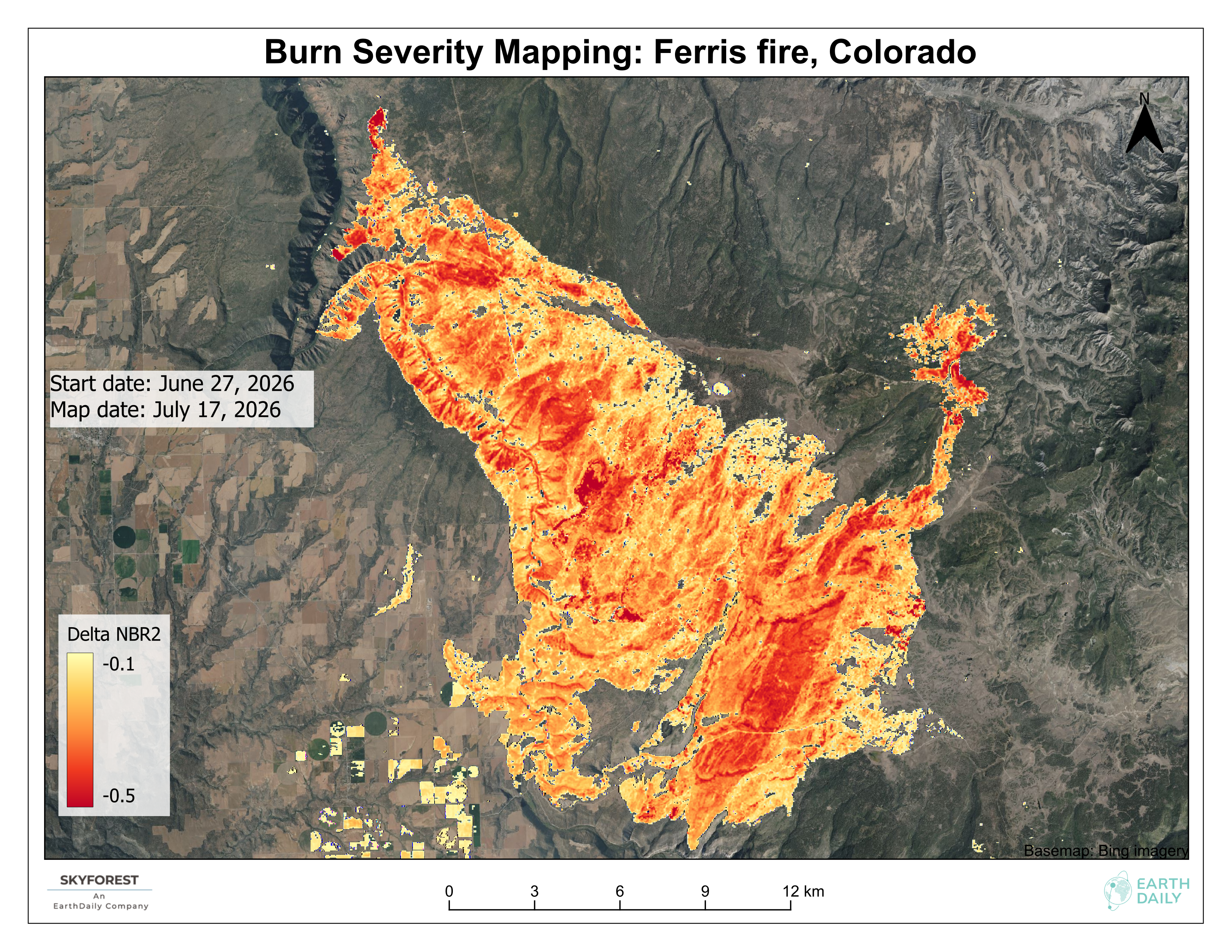
For recent fires in Colorado, Northern Ontario and Spain, EarthDaily’s SkyForest wildfire intelligence capabilities used an automated EarthPlatform workflow to produce updated burn severity assessments within minutes of the latest satellite image acquisition.
The Bottleneck is No Longer Whether Analysis Can be Done
The harder questions are:
- How quickly can it be delivered?
- How many fires can be processed at the same time?
- Can very large fire footprints be handled without creating a mosaicking bottleneck?
- Can the analysis distinguish fire damage from normal seasonal vegetation change?
- Can the result be updated repeatedly as new satellite observations arrive?
Traditional approaches often rely on manual image selection, downloading, mosaicking, change detection, classification and quality control. That may be manageable for one fire. It becomes much harder when multiple incidents are active across large or difficult-to-access areas.
Accuracy adds another challenge. Vegetation changes naturally through the season, so comparing a post-fire image with a single recent baseline can mistake seasonal change for fire damage.
EarthPlatform addresses this by comparing each pixel with its own historical condition at approximately the same time of year across the previous three years, then rerunning the assessment as new observations become available.
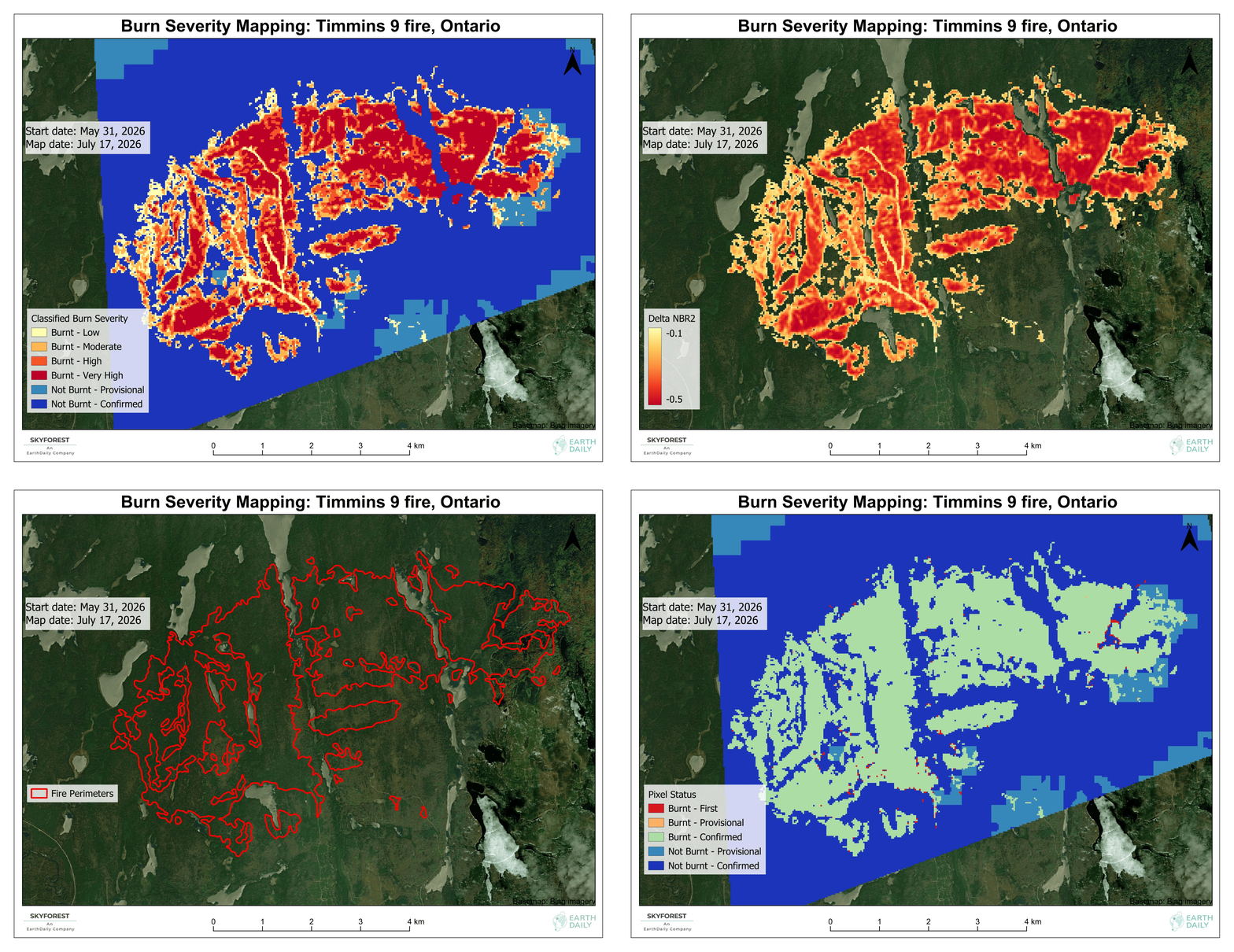
Ontario: Mapping While the Fire is Still Active
Northern Ontario’s wildfire emergency unfolded across vast, difficult-to-access terrain, with evacuations ongoing and smoke travelling far beyond the fire zone.
The Timmins 9 assessment provided a current view across that terrain while the wildfire emergency was still evolving.
Colorado: Comparing Fires Across Different Landscapes
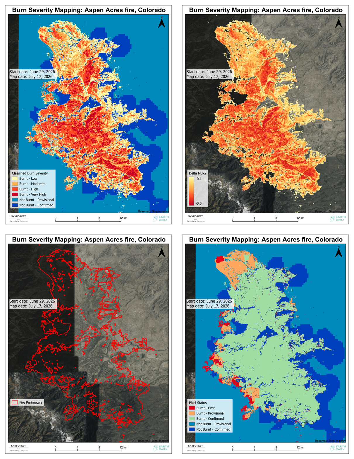
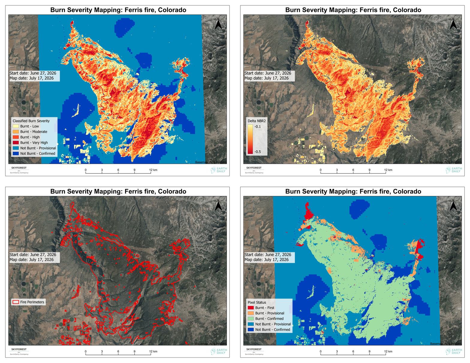
The Aspen Acres and Ferris fires burned across very different terrain, each leaving a large and complex footprint.
Applying the same automated workflow to both fires provided a consistent view across separate incidents and landscapes.
Spain: Assessing a Major Wildfire in Almería
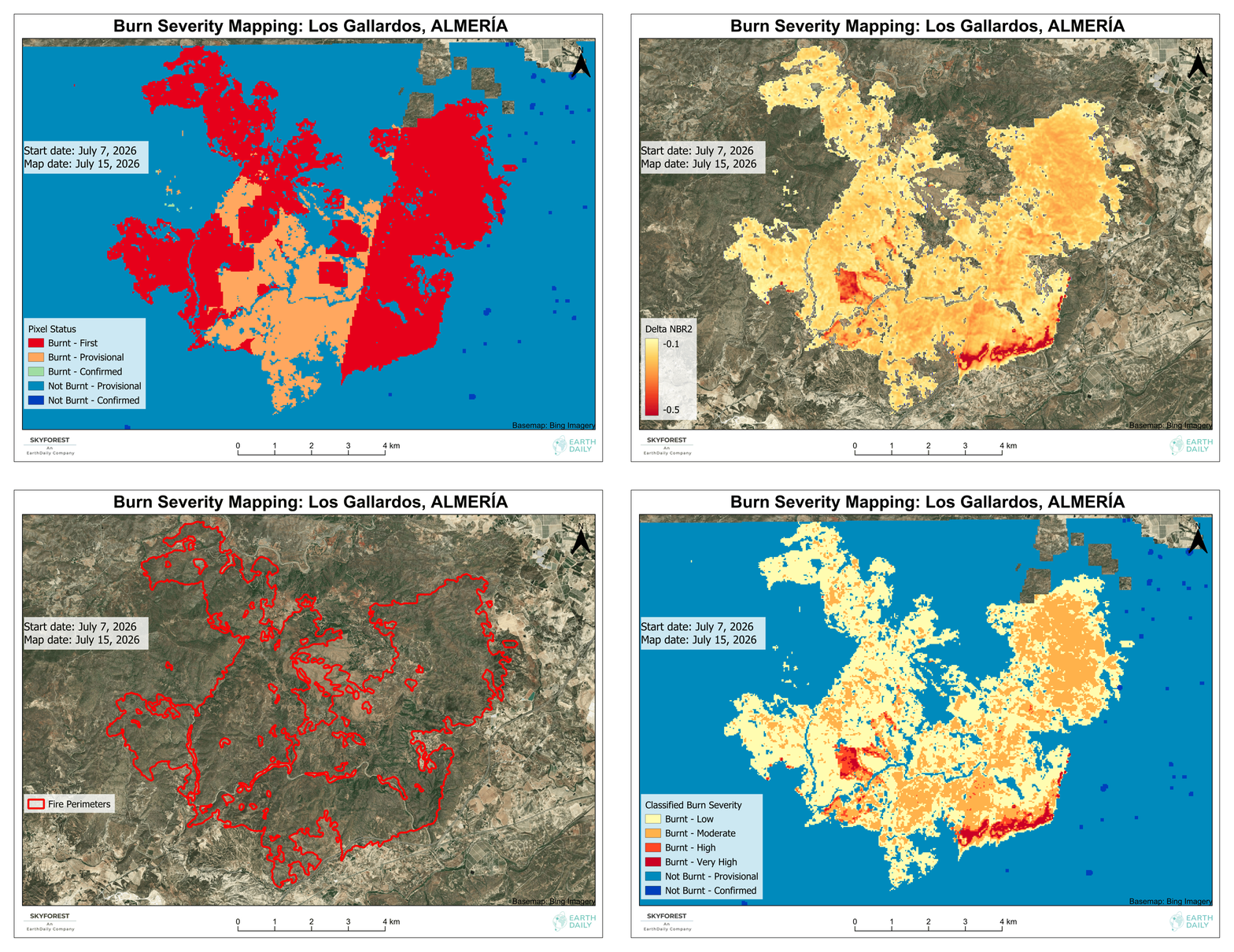
The Los Gallardos wildfire became one of the deadliest wildfire events in Spain’s history. The assessment showed how the same automated process can provide a detailed view of damage across a complex fire perimeter.
One Workflow Across all Three Fires
Across all three examples, the automated EarthPlatform workflow handled:
- Downloading and mosaicking satellite imagery
- Change detection
- Severity classification
- Fire-perimeter mapping
- Pixel-level quality assurance
- Final map production
The resulting dataset included:
- Spectral change magnitude
- Low, Moderate, High and Very High burn severity classes
- A mapped fire perimeter
- Pixel-level confidence flags showing whether classifications were provisional or confirmed
- Updated assessments as new observations became available
The process can be rerun after each new satellite image acquisition, allowing the fire footprint and severity assessment to be refined as more burned and unburned areas are confirmed.
Why Timing and Accuracy Matter
Burn severity is not simply a record of what happened. It supports decisions that begin while the situation is still evolving and continue through recovery.
For the forest industry
Forestry companies need to plan and execute timber salvage before beetles affect the damaged wood. An accurate severity assessment helps them:
- Identify the right wood to salvage
- Target the appropriate areas
- Begin salvage planning early
For government
Government agencies need burn severity information to begin:
- Tree-planting plans
- Field surveys to assess damage
- Ecological impact assessments
- Regulatory reporting
Accuracy matters because these activities depend on understanding where damage occurred and how severe it was.
For insurance
Insurers need early information to begin:
- Claims adjustment
- Claims planning
- Identifying potentially affected areas
- Helping customers affected by wildfire
Accuracy has immediate financial implications. Early damage intelligence gives insurance teams a head start while the fire is still evolving. Burn severity mapping is already widely understood. The challenge is delivering it quickly enough, accurately enough and at the scale required when multiple fires are active and decisions cannot wait.
See EarthDaily’s automated burn severity mapping in action.
About the Author