.jpg?width=289&height=168&name=Data%20Use%20cases%20(1).jpg)
The planet does not wait for a monthly briefing. Conditions shift and new signals emerge every day. Once a month, The EarthDaily Monitor will bring four of those signals into focus, using EarthDaily data, analysis and expertise to show what is changing, why it matters and what to watch next.
September made clear that climate risk is moving faster, and more unevenly, than the systems built to price and finance it — catastrophe losses across the world continued to show how quickly a changing hazard can outrun the assumptions behind it.
The same underlying pressure showed up in agriculture, wildfire and the expectations shaping EO itself: an uneven global crop outlook, record early-year wildfire activity and growing demands for measurement quality, openness and continuity. Each signal points to the same underlying question: not just what is changing, but whether the data behind it holds up to scrutiny.
01 Lead Signal
Climate Risk Is Demanding Continuous Evidence
Climate risk is moving faster than the assumptions used to price, finance and manage it, increasing demand for evidence showing where exposure is changing and whether resilience measures are working.
The underlying risk: Swiss Re estimates that natural catastrophes caused US$100 billion in global economic losses during the first half of 2026, of which US$42 billion was insured. Though below recent averages, the reinsurer cautioned that underlying risk remains: rising reconstruction costs and growing concentrations of homes, businesses and infrastructure in hazard-prone areas continue to drive the long-term trend.
From pledges to implementation: At the UN launch of the COP31 Action Agenda in New York, the presidency presented its framework for turning climate commitments into measurable results. Later, during Climate Week NYC, it named the first five pilot countries for the Climate Implementation Bridge and launched a financing facility with UN-Habitat and the World Bank to move urban resilience plans toward investment and delivery.
Why it matters: When hazards exceed historical assumptions, resilience decisions need current evidence. Continuous observations reveal changing exposure, guide investment and show whether interventions are reducing risk.
02 Agriculture
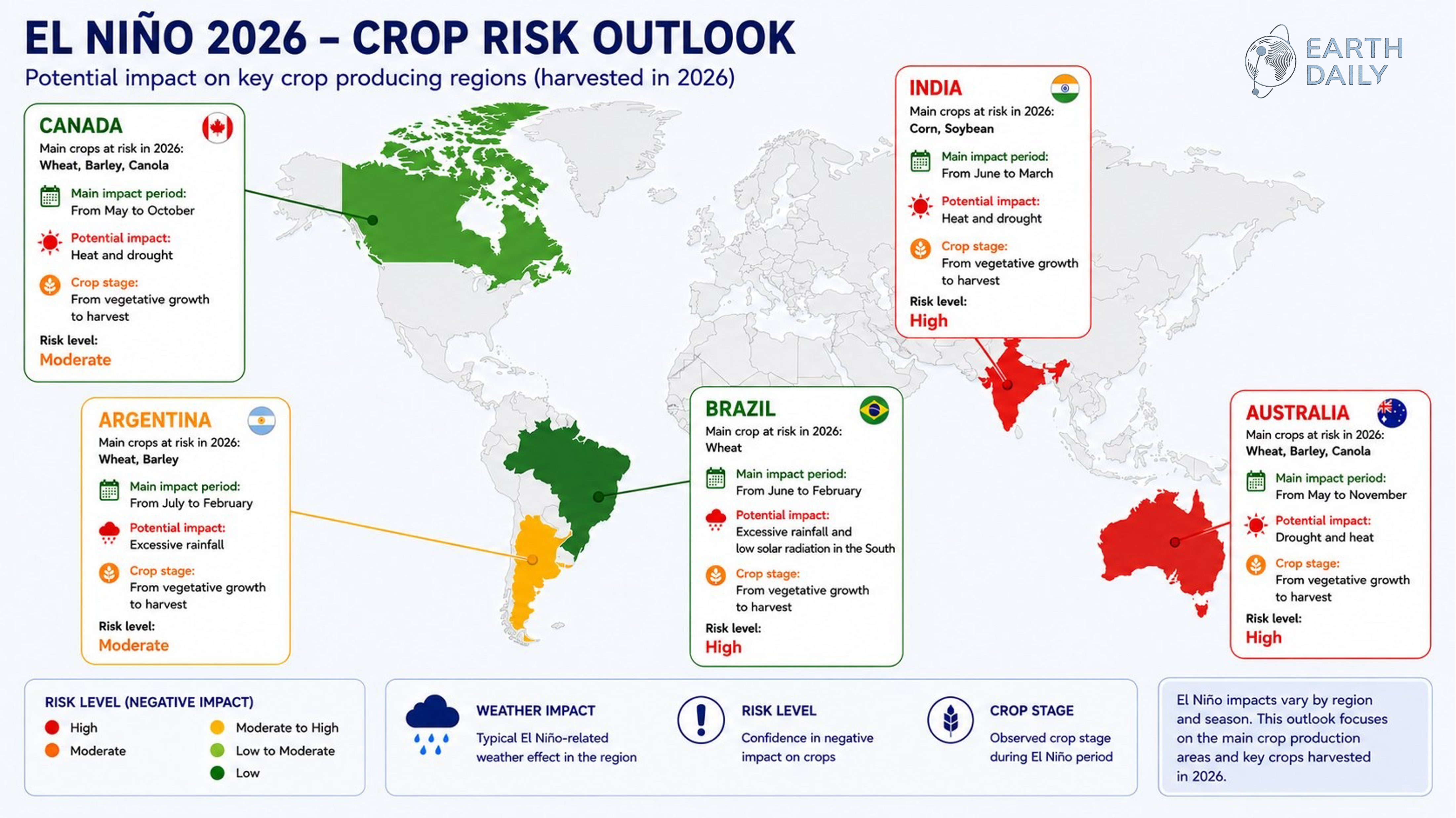
El Niño Is Adding to an Uneven Global Crop Outlook
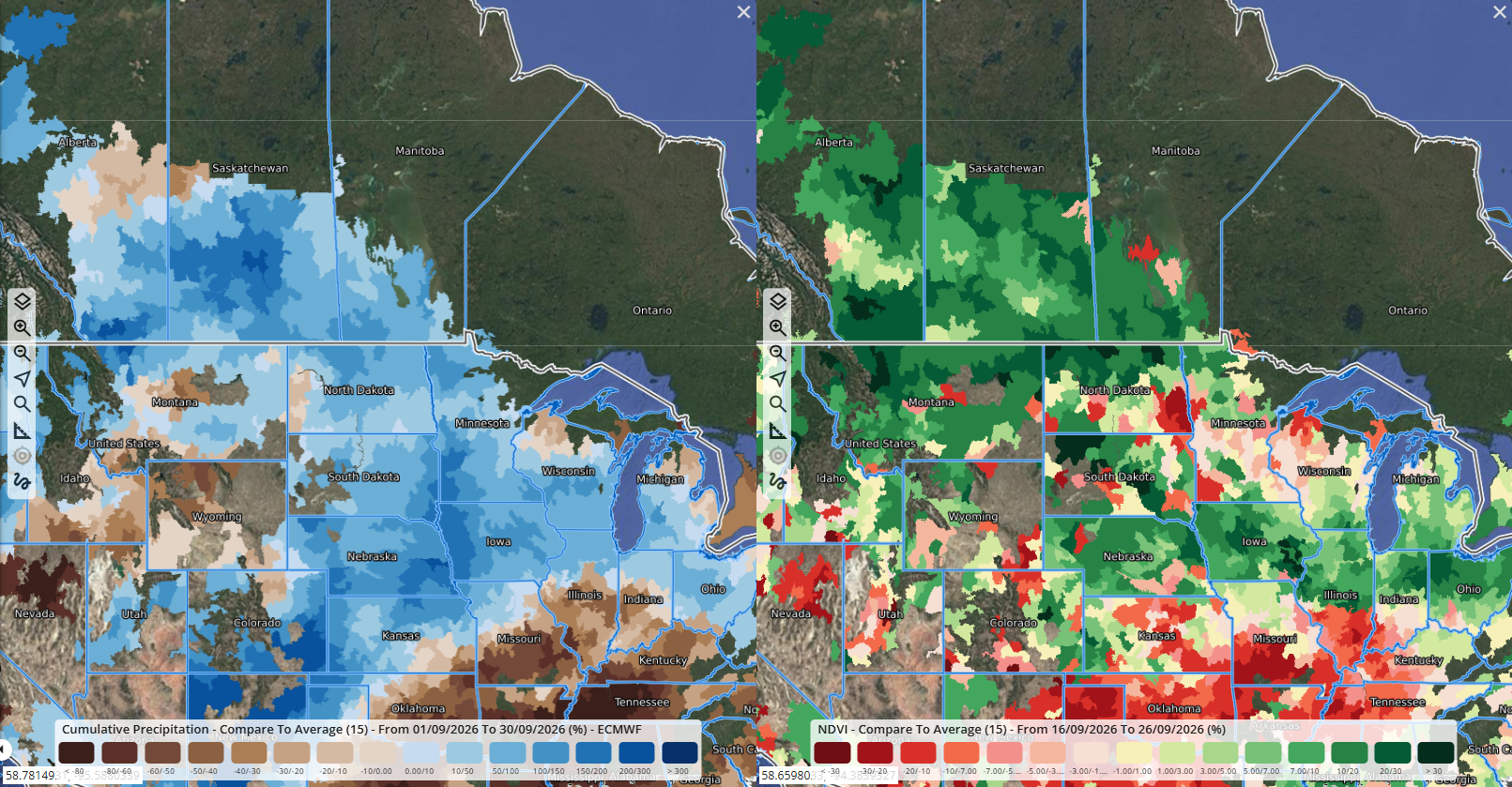
A particularly wet September across much of Canada’s wheat belt and the US Corn Belt supported late-season yields, but grain quality risks will need monitoring in October.
Crop conditions are diverging across major growing regions, increasing the value of intelligence that connects the global outlook with field-level change.
The climate backdrop: The WMO expects El Niño to strengthen and persist into early 2027, raising drought risk in some regions and excess rainfall in others. EarthDaily’s latest World in 10 outlook shows the unevenness: dryness is pressuring winter crops in Argentina and Australia and complicating wheat planting in Europe, while the U.S. Corn Belt holds steady.
Closer to the field: EarthDaily's field- and township-scale analysis of recent U.S. storm damage shows how regional weather risk becomes measurable change on the ground. In a separate video, EarthDaily's Lee Smith explains how consistent, calibrated and analysis-ready observations can make agricultural intelligence operational, while Christina Collins shows how EarthDaily Territory Insights applies crop identification, performance monitoring and analytics across entire territories.
Why it matters: Agricultural risk develops unevenly. Field boundaries and repeat measurements show where damage occurred, how widely it spread and where closer assessment is needed.
03 Wildfires
Wildfire Risk Is Breaking Familiar Patterns
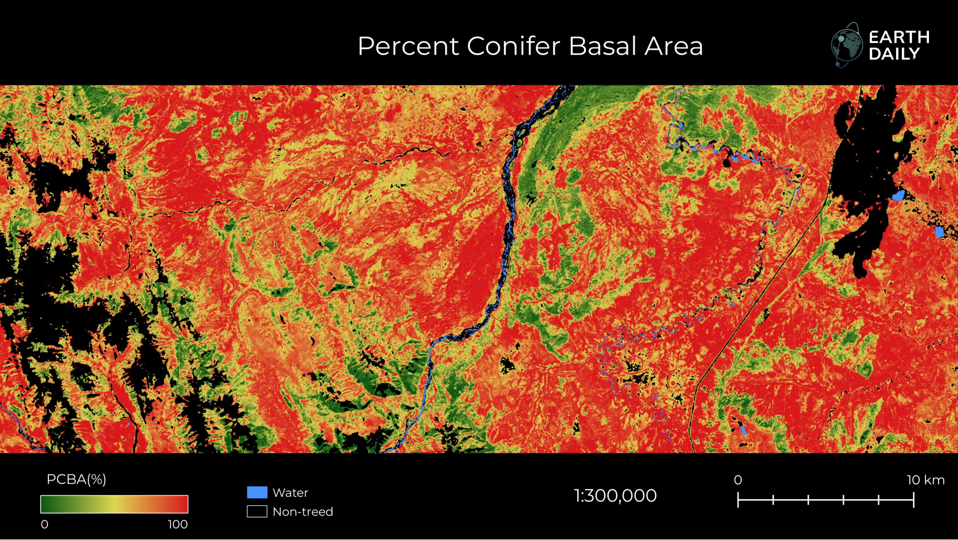
Percent Conifer Basal Area (PCBA) across Canada. Source: EarthDaily.
More land burned globally in the first four months of 2026 than in any comparable period on record. Attribution studies published since have shown that climate change is measurably raising the likelihood of extreme fire weather.
Not a seasonal blip: World Weather Attribution found more than 150 million hectares burned worldwide between January and April, 20% above the previous record and nearly double the same period in 2024. WWA has since linked the conditions behind specific events to climate change directly: extreme fire weather in the Northwest Territories and Ontario was found roughly twice as likely, and in Spain, fire-weather conditions were at least 20 times more likely.
From fuel to financial exposure: The same landscape conditions now shape two decisions — where fuel-reduction work should focus, and where insurers may carry concentrated exposure. EarthDaily's FLAIM identifies where hazard is building. Aon's Impact Forecasting is using EarthDaily's wildfire-validated forest-composition data in a Canadian catastrophe model, placing mitigation planning and financial risk assessment on a shared evidence base.
Why it matters: When once-rare fire-weather conditions become more likely, mitigation planning and financial models need current evidence rather than historical assumptions.
04 Decision-Grade EO
Continuity and Trust Are Defining Operational EO
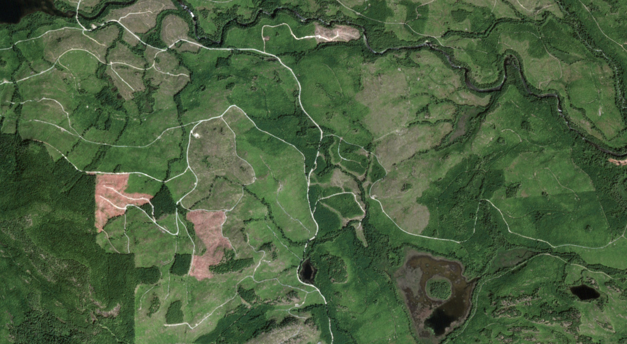
Port Alberni, Vancouver Island. Captured by EarthDaily Constellation in June 2026
Recent developments sharpened expectations across the EO chain: continuity for public programs, measurement quality for commercial data and clearer routes into public-sector use.
Continuity and openness: At the International Space Summit in Paris, 49 countries and ESA backed principles of accessibility, openness, integrity and international cooperation in space-based scientific data. In the United States, NASA and USGS moved Landsat 10 into procurement, advancing a mission intended to extend the program’s continuous record within its established open-data model.
Measurement quality: A new EarthDaily analysis examines the standards NASA, ESA and USGS expect of commercial optical data. NASA and USGS are separately exploring commercial Landsat-like products, bringing continuity, comparability and open access into focus. In Canada, EarthDaily’s approval under the NMSO provides an established route into federal procurement.
Why it matters: Operational workflows need both: a continuous public record and commercial measurements that can be trusted alongside it.
Video Spotlight •
Chris Rampersad on What Makes Data Science-Grade
Science-grade Earth observation is built across the entire measurement chain: a stable spacecraft, a scientific payload, calibration traceable to standards, in-orbit calibration and a ground system that turns raw signals into accurately located physical measurements.
In this video, Chris Rampersad, Senior Vice President, Analytics at EarthDaily, explains how those elements build on one another, and why a shortcut at any stage can limit the quality of the final product..png?width=824&height=464&name=Chris%20R%20(2).png)
People Behind the Data
.png?width=200&height=200&name=Will%20Parkinson%20(1).png)
William Parkinson on Why the Picture Is Only the Beginning
A compelling image can show that something happened. The harder question is whether it tells someone what to do next. That goes beyond taking a picture with a camera in space: the measurement must be reliable, the signal must arrive in time and the result must reach the user in a form that fits the decision they need to make.
William Parkinson, Technical Product Director at EarthDaily, says that is the real test for any Earth observation product: "A good image can get your attention. Quality is what earns your trust. When you can trust the measurement consistently, you can build AI-enabled services on top of it—and turn Earth observation into operational decisions at scale."
Why it matters: The value of Earth observation isn't the image itself. It is whether the product built on top of it gets someone to a decision faster. That is the translation work that turns measurement into something usable.
New Whitepaper
Science-Grade Earth Observation Data: From Imagery to Measurement
“Science-grade” is often used as shorthand for “high quality,” but it has a specific meaning: data calibrated, independently validated and consistent enough to measure change accurately over time. EarthDaily’s new whitepaper argues that much of the Earth observation market still delivers imagery when operational decisions require measurement. It explains what closing that gap requires at the system level.
Download the Whitepaper
EarthDaily in the News

More From The Newsroom
-
Two of the world's largest mining companies have renewed their use of EarthDaily's mineral intelligence platform, one following a competitive evaluation. Read More
-
A five-year agreement integrates Iris deformation intelligence directly into a global engineering firm's tailings management platform. Read More
-
How daily satellite monitoring and AI-powered change detection can close surveillance gaps across long, remote border regions. Read More
The Monitor Watchlist
The months ahead will show whether these signals compound or begin to ease. EarthDaily will keep a close watch on:
- El Niño's next phase: WMO expects the event to peak in the coming months, likely widening the regional crop divergence covered in this issue.
- Catastrophe risk shifts basins: Atlantic activity turns toward the Caribbean and Gulf as the season progresses, while the Western Pacific stays in its most active typhoon window.
- Fire risk shifts south: As Australia enters spring under a strengthening El Niño, attention shifts to how fire weather and fuel conditions develop across the Southern Hemisphere.
- Commercial data expectations keep evolving: NASA and USGS continue exploring whether commercial providers could support Landsat-like products, while the joint optical guidelines separately raise expectations for calibration, validation and comparability.
Don’t Miss the Next Signal
The EarthDaily Monitor brings four signals into focus every month, with the data, analysis, deployments and expertise needed to understand what is changing and what to watch next.
About the Author

.png)